Cumberland Trail Highlights
Notification Alert
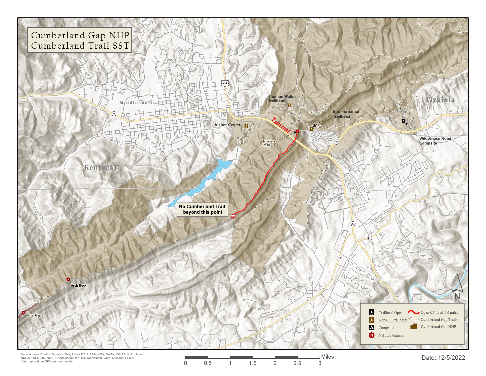
Cumberland Trail Need to Know
Please exercise extreme caution while enjoying creek areas, including waterfalls. Water levels may change suddenly, running high and moving fast in many areas and posing increased safety risk. Check out our interactive map to plan your trip.
All Counties: All caves on lands managed by the Cumberland Trail State Scenic Trail are closed to the public at this time due to White Nose Syndrome.
A Trail That Brings Tennessee Together
The Cumberland Trail is a statewide connector linking landscapes, communities, and conservation efforts across Tennessee. Spanning 11 counties, the trail intersects with national park lands, state parks, natural areas, wildlife management areas, and neighboring state borders to form a continuous corridor of protected land and public access. Beyond the terrain, the Cumberland Trail unites a diverse network of local friends groups, nonprofit partners, and volunteers, all contributing to a shared mission of stewardship, outdoor recreation, and long-term conservation. Together, these connections make the Cumberland Trail one of Tennessee’s most significant and collaborative outdoor projects.
Discover Justin P. Wilson Cumberland Trail State Park
The Cumberland Trail is a testament to the power of vision and perseverance. Conceived in the 1970s by a group of passionate hikers (Mac Prichard, Evan Means, Bob Brown, and Sam Powell), the trail aimed to connect existing natural areas and create a continuous hiking experience across the Cumberland Plateau.
The dream to create the Cumberland Trail took root in 1971 when the State Scenic Trails Act was signed by Governor Winfield Dunn. But it wasn't until 1998 that Cumberland Trail State Park became the 53rd state park. In 2002, it was renamed to Justin P. Wilson State Park in honor of his commitment to complete this spectacular 11-county corridor. Wilson was Tennessee’s Deputy Governor from 1996 to 2003 and served six terms as Tennessee’s 34th Comptroller from 2009 to 2021.

History
The story of Cumberland Trail State Park is intertwined with the history of the Cumberland Plateau itself.
The trail follows ancient pathways used by Native American tribes for hunting and trade, and later by pioneers and settlers venturing westward. The region's rich natural resources fueled industries like mining and logging, leaving behind remnants of railways and settlements that whisper tales of a bygone era.
The Cumberland Trail follows a line of pristine high ridges and deep gorges lying along Tennessee’s Cumberland Plateau, linking state park lands, state natural areas, wildlife management areas, and national parks. As it meanders, the trail travels through several natural areas: Laurel-Snow, Ozone Falls, and Stinging Fork. It also borders Piney Falls. Partnership with the Cumberland Trails Conference, Friends of the Cumberland Trail, and other 501c3 organizations and volunteer groups supports the acquisition of land and the construction and maintenance of the trail. The completed trail corridor will encompass the largest acreage within a Tennessee State Park unit, extending from the Cumberland Gap on the Tennessee, Virginia, and Kentucky borders to the Tennessee River Gorge near Chattanooga.
Today, the park protects numerous historical and cultural sites, including Devilstep Hollow Cave, adorned with Mississippian-era glyphs, and Head of Sequatchie Spring, the source of the Sequatchie River. The farm at Head of Sequatchie was owned by Adam Sherill, a Revolutionary War veteran, and his sister Bonnie Kate Sherill, who married John Sevier, the state's first governor. The park is also tied to the Dayton Coal Mines and the Fratersville Mine, the site of a tragic mining accident.
Cumberland Trail State Park is a living museum, where every step reveals a new chapter in the story of Tennessee.
From the Rangers
-
The Perfect Day
A perfect day on the Cumberland Trail starts with a sunrise hike to Black Mountain Overlook or, if you're up for a nine-mile hike, you can go to Laurel Falls, where you can view hundreds of waterfalls and the Cumberland Trail corridor. In the afternoon, immerse yourself in history at the Head of Sequatchie Visitor Center, before ending the day with a relaxing evening under the stars at a backcountry campsite.
-
Inside Information
While many flock to the popular trailheads, true adventurers seek out the lesser-known sections of the Cumberland Trail. Piney River offers a secluded escape into a world of untouched beauty. Here, you can discover waterfalls, pristine swimming holes, and breathtaking overlooks, all without crowds.
-
Know Before You Go
The Cumberland Trail is a wilderness experience, so come prepared! Cell service is limited in many areas, so download maps and trail information beforehand. Be aware of the potential for flash flooding in creeks and river gorges and always check the weather forecast before heading out.


Trails
The Cumberland Trail is the main attraction, offering over 300 miles of hiking opportunities, from short day hikes to multi-day backpacking trips. With over 25 trailheads and points of access, there's a section of the trail to suit every skill level and interest.
-
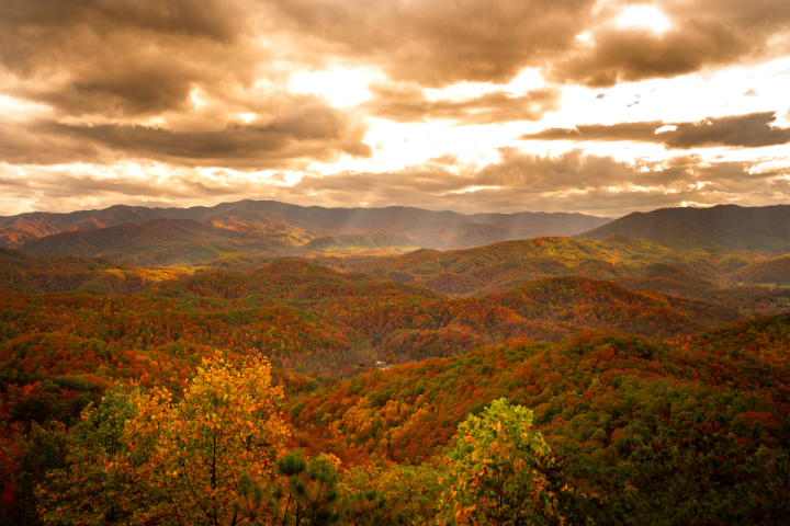
Mountains and Vistas
The Cumberland Trail traverses the rugged terrain of the Cumberland Mountains, offering countless opportunities to reach breathtaking peaks and summits.
Hike to Black Mountain, Hinch Mountain, or Brady Mountain for panoramic views that stretch across the Tennessee landscape.
-
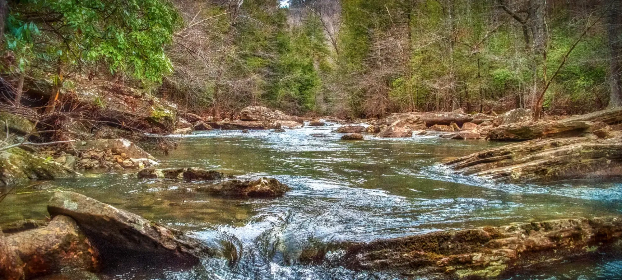
Water Features
The Cumberland Trail is a water lover's paradise, with hundreds of streams, countless waterfalls, rivers, and creeks cascading through the landscape. Hike to the Laurel-Snow State Natural Area to witness the beauty of Laurel Falls, or explore the Obed, New, and Emory Rivers.


Plants
The Cumberland Trail boasts a diverse array of flora, with wildflowers blooming in the spring and vibrant fall foliage painting the landscape in autumn.
Come and learn from a Park Ranger about the unique plant life of the Cumberland Plateau, including hardwoods and wildflowers.
The entire Cumberland Trail has extraordinary seasonal wildflower viewing.

Plant Types
- Wildflowers (General)

Animals
The Cumberland Trail is home to a variety of wildlife.
Keep an eye out as you explore the park and learn about the habitats and behavior of our fauna from a knowledgeable Park Ranger.
Animal Species
- Deer
- Black Bear
- Elk
- Raccoon
Inspiration
-

Wonderful Winter Hikes in Tennessee
Wonderful Winter Hikes in Tennessee - Read ArticleWinter is one of the best times to hike at Tennessee State Parks, with quiet trails, fewer bugs, clear views, and dramatic landscapes of icicles and fresh snow. -
Unique Ways to Experience Fall Foliage in Tennessee
Unique Ways to Experience Fall Foliage in Tennessee - Read ArticleAs leaves change color and crisp air settles in, it's the perfect time to explore Tennessee's natural beauty. With over 60 state parks, you'll find countless opportunities to witness autumn's vibrant hues. Here are some unique suggestions for viewing fall foliage—including what to do and where to visit. -

8 Tennessee State Parks Add Adult-Sized Changing Tables
8 Tennessee State Parks Add Adult-Sized Changing Tables - Read ArticleJune 16, 2025 | FOR IMMEDIATE RELEASE: Monday, June 16, 2025


