North Chickamauga Creek Gorge Highlights
Warning Alert
Closures Due To Improvement Project
Important alert for all visitors:
Beginning March 23, 2026 and lasting for approximately one year, improvements will be made to create a safer, more accessible experience for visitors. This includes paving the parking area, improving the park entrance, adding an ADA-accessible river viewing pier, and installing a restroom.
During this time, the following areas will be closed and inaccessible:
- Montlake Road Entrance and the Main Trailhead
- Blue Hole Trail & Blue Hole Access
- Hogskin Loop Trail
- Stripmine Falls
- Cumberland Trail from the Main Trailhead to Boston Branch Overlook
Learn more and view the map of the closed area on our safety information page.
Know Before You Go
The park often experiences high visitation. Please do not park on roadsides or in non-designated areas. If the park is full, please consider visiting another state park in the area.
Access to all areas along the creek may close due to inclement weather and/or rising waters. A four-point, color-coded rating system is used to determine the closing of creek access areas. Rangers and staff may close areas with little to no notice to park visitors. Learn more on our safety information page.
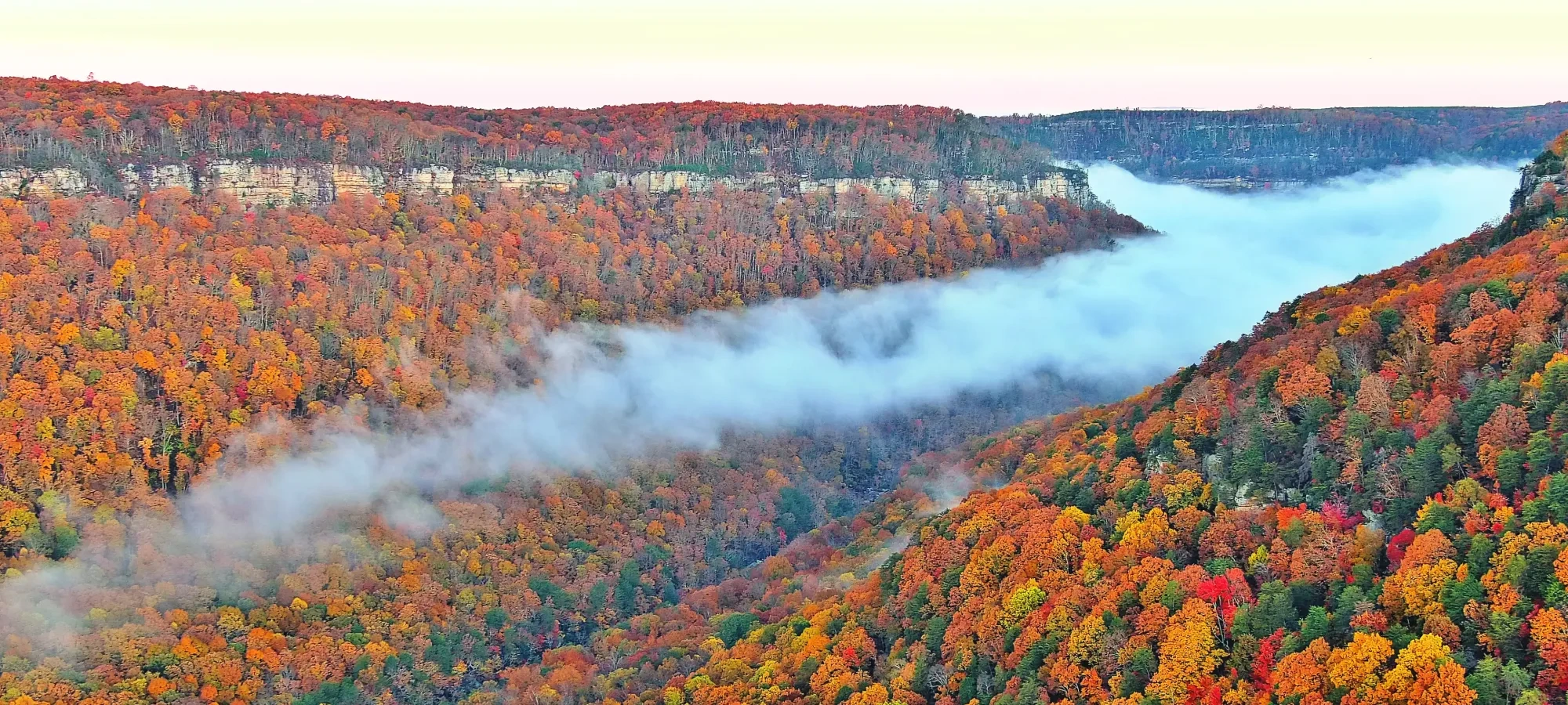
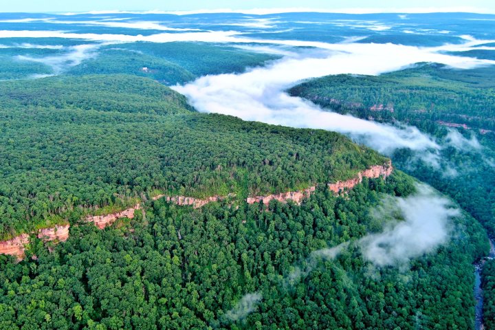
A Gorge-ous Escape
Discover the stunning beauty of the Cumberland Plateau at North Chickamauga Creek Gorge State Park, a rugged wilderness where sandstone cliffs meet the rushing waters of North Chickamauga Creek. This relatively new park offers a haven for outdoor enthusiasts seeking challenging hikes, stunning overlooks, and a chance to reconnect with nature.
Discover North Chickamauga Creek Gorge State Park
North Chickamauga Creek Gorge State Park encompasses more than 6,000 acres in Hamilton County. The deep gorge cut into the sandstone plateau of Walden’s Ridge on the Cumberland Plateau is approximately 10 miles long with steep slopes, sandstone bluffs, and rich coves. A high diversity of plant and animal habitat exists in the gorge.
The park also offers a sanctuary for both wildlife and those seeking solace in the wild. The park's rugged terrain and diverse habitats offer a unique blend of adventure and tranquility, inviting visitors to explore its hidden corners and discover the beauty of the Cumberland Plateau. Come experience the challenge and reward of exploring this relatively untouched wilderness, where the spirit of adventure awaits around every bend.
History
Established in 2024, North Chickamauga Creek Gorge State Park's story is intertwined with the land itself.
Before becoming a state park, it was a State Natural Area, cooperatively managed by State Natural Areas and the Cumberland Trail Conference. Before that, it was opened to the public as the Bowater Pocket Wilderness.
The area's history extends far beyond its designation as a protected space. Coal mining and the timber industry once thrived here, leaving their mark on the landscape. The Chickamauga Cherokee people historically used this area, adding another layer to its story. While no historical structures remain within the park, the echoes of these past industries and the presence of the Cherokee people resonate throughout the gorge. The park's name is derived from the creek that flows through it, North Chickamauga Creek, a name that reflects the area's deep connection to the Chickamauga Cherokee.
From the Rangers
-
The Perfect Day
Follow the Upper Loop of the Hogskin Branch Trail to reach the Cumberland Trail. Enjoy waterfall views at Stripmine Falls before you hike on to the park’s most breathtaking vista at Boston Branch Overlook.
-
Insider Information
To truly experience the solitude of North Chickamauga Creek Gorge State Park, plan your visit when school is in session. Weekdays in winter offer the quietest experience, with less foliage providing outstanding views. However, be prepared for limited services and potentially challenging conditions during the colder months.
-
Know Before You Go
Be aware that cell service is unreliable beyond the trailhead areas. The park closes at 7 PM EST, so plan your visit accordingly. Parking can be scarce, so visitors should have a backup plan should the park reach capacity. RVs should not attempt to enter the park as the crowded parking lot offers little room for larger vehicles to navigate. Also, please note that the Blue Hole Trail may be closed without notice due to unsafe river conditions.


Land and Water
-
Trails
North Chickamauga is a true wilderness offering access to breathtaking views, peaceful hikes and unforgettable experiences. The park boasts a network of challenging trails, including roughly nine miles of the Cumberland Trail. These trails wind through rugged terrain, offering stunning views and access to remote areas of the gorge. Be prepared for steep inclines, loose footing, and slippery surfaces.
-
Mountains and Vistas
As part of the Southern Appalachian and Cumberland Mountain ranges, North Chickamauga Creek Gorge State Park offers several overlooks with stunning views. The Boston Branch Overlook and sections of the Flipper Bend Trail provide expansive views of the gorge and the surrounding landscape.
-
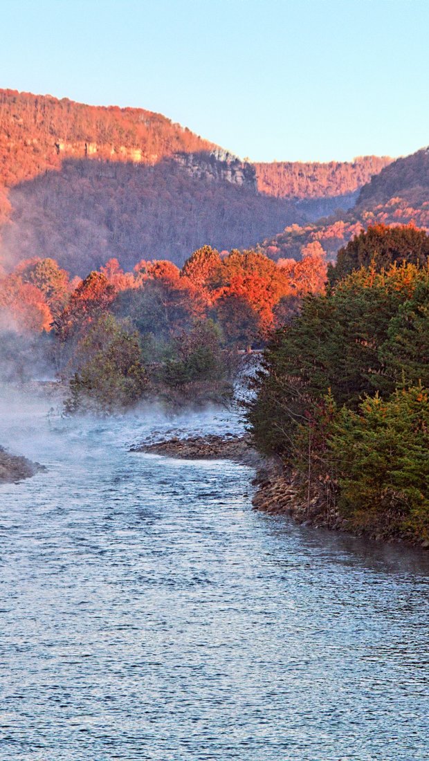
Water Features
The park features its namesake creek, North Chickamauga Creek, and several smaller creeks. These waterways offer opportunities for wading and kayaking, but visitors should be aware of the potential for dangerously swift currents and flash flooding.


Our Creeks
North Chickamauga Creek Gorge State Park has several crystal clear creeks with a striking blue-green hue.
The creeks that pass through the park include:
- North Chickamauga Creek
- Boston Branch
- Clear Branch
- Cooper Creek
- Hixon Branch
- Hogskin Branch
- Mossy Creek
- Panther Branch
- Rogers Creek
- Stevenson Branch
These waterways offer opportunities for wading and kayaking, but visitors should be aware of the potential for dangerously swift currents and flash flooding.
There are several access points on the main trail near North Chickamauga. These are easily accessible but do require using rock stairs. The more remote creeks in the park can offer a deep sense of solitude, adventure, and wilderness.

Our Waterfalls

Plants
The park is home to small pockets of old-growth forest with tulip poplar, yellow buckeye, and basswood found in remote locations where rugged topography has protected the forest from past logging.
On the uplands and bluffs, there are oak-hickory and oak-pine forests. Riverside shoals and stream cobble bars at North Chickamauga Creek provide habitat for several threatened and endangered plants. We have 10 state or federally listed plants in our park.
To promote conservation efforts and protect forest health, we encourage park guests to avoid going off-trail.
Plant Types
- Linden (Basswood)
- Hickory
- Pine Forests
- Tulip Poplar (Tulip Tree, State Tree)
- Large-flowered Skullcap
- Virginia Spiraea
- Yellow Buckeye

Birds
Bald eagles and peregrine falcons have been sighted at North Chickamauga Creek Gorge State Park.
Bird Species
- Bald Eagle
- Peregrine Falcon
- Carolina Chickadee
- Carolina Wren
- Northern Cardinal
- Red-eyed Vireo
- Tufted Titmouse
- Turkey Vulture
- American Crow
- Woodpecker spp.

Animals
North Chickamauga Creek Gorge State Park has a variety of common mammals such as deer, raccoon, coyote, and wild turkey to see as you meander through the trails in the park.
In addition to mammals, the park is home to lizards, snakes, salamanders, and fish. The Barker Camp side of the park will have more wildlife than the more residential area near Montlake Road.
Animal Species
- Coyote
- Deer
- Fish
- Opossums
- Raccoon
- Salamanders
- Squirrels
- Wild Turkey
- Copperhead
- Rat Snakes
- Rattlesnakes spp.
- Northern Black Racers
- Corn Snakes
- Milk Snakes
- Water Banded Snakes
- Rough Green Snakes
Inspiration
-
Tennessee State Parks To Discuss Site Management Plans, Receive Public Feedback for 14 State Parks
Tennessee State Parks To Discuss Site Management Plans, Receive Public Feedback for 14 State Parks - Read ArticleOctober 31, 2025 | NASHVILLE – Tennessee State Parks will hold public meetings across the state in the coming weeks to discuss site management plans specific to 14 parks. -
Improvement Projects To Result in Temporary Changes at North Chickamauga Creek Gorge State Park
Improvement Projects To Result in Temporary Changes at North Chickamauga Creek Gorge State Park - Read ArticleStarting in early 2026, North Chickamauga Creek Gorge State Park will undergo a major improvement project to enhance visitor access and amenities. While construction is underway, the main parking area will be closed, and access to the Blue Hole will be temporarily unavailable for approximately one year.

