Henry Horton Hiking

Warning Alert
Warning

Ongoing Construction at Henry Horton State Park

Henry Horton State Park

In anticipation of our new lodge opening, there will be a significant impact on the roads and traffic patterns within Henry Horton State Park. We ask that visitors please use caution and follow all road signs while traveling throughout the park's day-use area. A fence will surround the main construction area. 

Guests visiting the Visitor Center, Restaurant, Cabins, Shelters, and Conference Hall should expect modified traffic flow and clearly marked detour routes. With construction underway, guests may experience periods of loud construction noise.

Please note:

  • Some roads in the lodge area are temporarily closed.
  • All guests should follow posted DETOUR signage throughout the park.
  • Traffic patterns near the Lodge, Visitor Center, and Day-Use Parking have been adjusted.
  • A construction fence surrounds active work zones.
  • Guests may experience periods of loud construction noise.
  • Please drive slowly and use extra caution when traveling through the park.

Our team will be on-site assisting with directions and parking adjustments to help make your visit as smooth as possible.

We sincerely appreciate your patience and understanding as we begin these exciting enhancements to Henry Horton State Park. We look forward to sharing more soon!

If you have any questions or need assistance during this time, please call the lodge at 931-364-2222 or the park office at 931-364-7724. We look forward to welcoming you!

  • Dirt trail winding through a forest with fresh green grass and budding trees.
  • A wooden footbridge leading to a dirt trail surrounded by bright green vegetation and leafless trees under a clear blue sky.

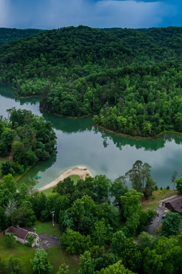
    Hiking at Henry Horton  

    Boasting over 20 miles of hiking trails, Henry Horton State Park is a wonderful place to get outside and into nature. The trails highlight a variety of terrain and rich ecosystems. Hikers have the opportunity to traverse through hardwood secondary growth forests, pine stands, along ridged sinkholes, barren limestone glades, and cedar thickets, near the Duck River, Spring Creek, and ephemeral ponds.

    The trails are color-coded on our map, which is available in person or online. Updated signage and meticulous trail maintenance make the hiking experience user-friendly and easy to navigate. Whether you are interested in a short hike in the woods or a long adventure across varying terrain, Henry Horton State Park has trails for everyone to enjoy.
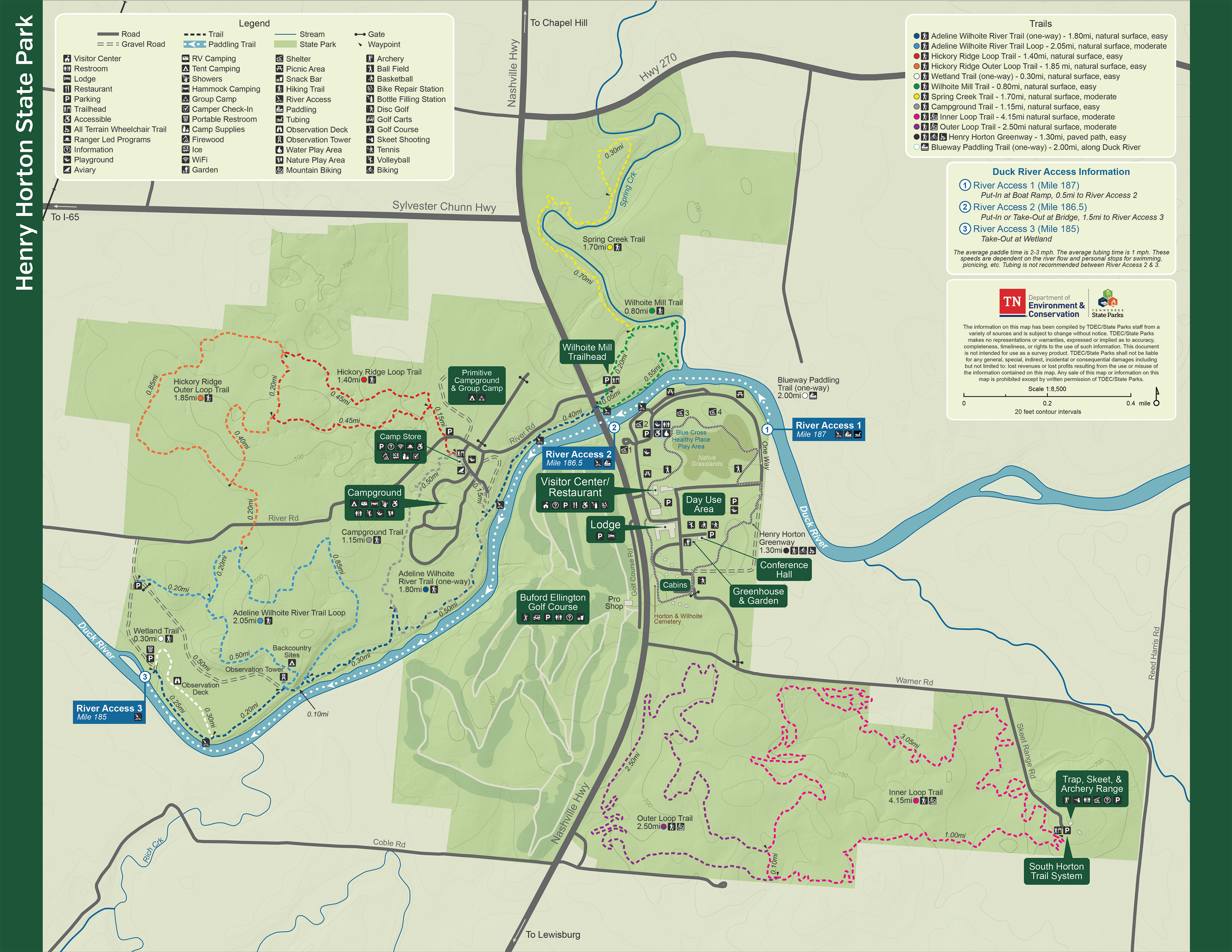
    Trails

    Showing page 1 of 2
    • Blueway Paddling Trail

      Henry Horton State Park
      Distance
      0.50 mi.
      Difficulty
      Surface
      Water
      Blueway Trail is a 2-mile water trail on the Duck River and is for kayaking/canoeing, tubing, or any water activity only.
      Availability
      Open
      Allowed
      paddle

      Campground Trail

      Henry Horton State Park
      Distance
      1.15 mi.
      Difficulty
      Surface
      Natural
      Availability
      Open
      Allowed
      Hiking

      Duck River Outer Loop Trail

      Henry Horton State Park
      Distance
      2.05 mi.
      Difficulty
      Difficult
      Surface
      Natural
      This trail runs parallel to the ecologically important Duck River, making it a great place to find fishing spots. This trail climbs to low wooded bluffs, through old fields, cedar glades, and grasslands. At 1.35 miles, there is a 20-foot observation tower overlooking a native grass field and wetland. It is here that the trail connects to the Wetland Trail and the Adeline Wilhoite River Trail Loop.
      Availability
      Open Seasonal
      Allowed
      Hiking

      Duck River Outer Loop Trail

      Henry Horton State Park
      This trail runs parallel to the ecologically important Duck River, making it a great place to find fishing spots. This trail climbs to low wooded bluffs, through old fields, cedar glades, and grasslands. At 1.35 miles, there is a 20-foot observation tower overlooking a native grass field and wetland. It is here that the trail connects to the Wetland Trail and the Adeline Wilhoite River Trail Loop.
      Distance
      2.05 mi.
      Difficulty
      Difficult
      Surface
      Natural
      Allowed
      Hiking

      Trail Type
      Information unavailable

      Elevation
      Gain 209.70'
      Loss 288.50'
      Grade
      Typical 4.2%
      Max 27.4%
      Cross Slope
      Typical 2.1%
      Max 22.6%
      Tread Width
      Typical 36"
      Minimum 16"
      Surface Type
      Soil 92.5%; Rock 4.5%; Gravel 2%; Wood decking 1%
      Obstructions Exist
      Step: 13 in tall; Tree roots: 8 in tall; Tree: 16 in of tread remaining

      Duck River Trail

      Henry Horton State Park
      Distance
      1.80 mi.
      Difficulty
      Difficult
      Surface
      Natural
      The trail follows the ecologically important Duck River, which makes it a great place to find fishing spots. At 1.35 miles, there is a 20-foot observation tower overlooking a native grass field and wetland. It is here the trail connects to the Wetland Trail and the Adeline Wilhoite River Trail Loop.
      Availability
      Open
      Allowed
      Hiking

      Duck River Trail

      Henry Horton State Park
      The trail follows the ecologically important Duck River, which makes it a great place to find fishing spots. At 1.35 miles, there is a 20-foot observation tower overlooking a native grass field and wetland. It is here the trail connects to the Wetland Trail and the Adeline Wilhoite River Trail Loop.
      Distance
      1.80 mi.
      Difficulty
      Difficult
      Surface
      Natural
      Allowed
      Hiking

      Trail Type
      Information unavailable

      Elevation
      Gain 136.30'
      Loss 143.70'
      Grade
      Typical 3.0%
      Max 28.6%
      Cross Slope
      Typical 2.7%
      Max 22.6%
      Tread Width
      Typical 58"
      Minimum 20"
      Surface Type
      Soil 64.6%; Mowed grass 24.8%; Gravel 9%; Wood decking 1.6%
      Obstructions Exist
      Step: 14 in tall; Step: 9 in tall; Tree roots: 8 in tall

      Henry Horton Greenway

      Henry Horton State Park
      Distance
      1.30 mi.
      Difficulty
      Easy
      Surface
      Paved

      The Greenway is a 1.5-mile accessible paved trail that winds through the park's most notable features.

      Availability
      Open
      Allowed
      Biking Hiking wheelchair

      Hickory Ridge Loop Trail

      Henry Horton State Park
      Distance
      1.40 mi.
      Difficulty
      Difficult
      Surface
      Natural
      The trail showcases some of the park's most different ecosystems, sinkholes, and cedar glades. Both are places of rich diversity and contain plants and animals that are not found in any other type of landscape.
      Availability
      Open
      Allowed
      Hiking

      Hickory Ridge Loop Trail

      Henry Horton State Park
      The trail showcases some of the park's most different ecosystems, sinkholes, and cedar glades. Both are places of rich diversity and contain plants and animals that are not found in any other type of landscape.
      Distance
      1.40 mi.
      Difficulty
      Difficult
      Surface
      Natural
      Allowed
      Hiking

      Trail Type
      Information unavailable

      Elevation
      Gain 88.10'
      Loss 130.70'
      Grade
      Typical 2.9%
      Max 26.2%
      Cross Slope
      Typical 2.0%
      Max 12.5%
      Tread Width
      Typical 41"
      Minimum 12"
      Surface Type
      Soil 88.4%; Rock 7.6%; Gravel 2.4%; Asphalt 1.6%
      Obstructions Exist
      Large Rocks: 14 in tall; Rock: 12 in tall; Large rocks: 10 in tall

      Hickory Ridge Outer Loop Trail

      Henry Horton State Park
      Distance
      1.85 mi.
      Difficulty
      Moderate
      Surface
      Natural
      Availability
      Open
      Allowed
      Hiking

      Hootin' Holler Mountain Bike Trail

      Henry Horton State Park
      Distance
      4.70 mi.
      Difficulty
      Surface
      Natural
      Availability
      Open
      Allowed
      Mountain Biking

      Inner Loop Multi-Use Trail

      Henry Horton State Park
      Distance
      4.15 mi.
      Difficulty
      Surface
      Natural
      Availability
      Open
      Allowed
      Hiking Mountain Biking
    • Learning Trail

      Henry Horton State Park
      Distance
      0.25 mi.
      Difficulty
      Surface
      Paved
      Availability
      Open
      Allowed
      Biking Hiking storybook wheelchair all_terrain_wheelchair

      Outer Loop Multi-Use Trail

      Henry Horton State Park
      Distance
      2.50 mi.
      Difficulty
      Surface
      Natural
      Availability
      Open
      Allowed
      Hiking Mountain Biking

      Spring Creek Trail

      Henry Horton State Park
      Distance
      1.70 mi.
      Difficulty
      Difficult
      Surface
      Natural
      Availability
      Open
      Allowed
      Hiking

      Spring Creek Trail

      Henry Horton State Park
      Distance
      1.70 mi.
      Difficulty
      Difficult
      Surface
      Natural
      Allowed
      Hiking

      Trail Type
      Information unavailable

      Elevation
      Gain 208.10'
      Loss 177.30'
      Grade
      Typical 3.7%
      Max 37.4%
      Cross Slope
      Typical 1.8%
      Max 14.9%
      Tread Width
      Typical 32"
      Minimum 12"
      Surface Type
      Soil 90.4%; Bedrock 6.3%; Wood decking 2.2%; Stairs 0.7%; Rock 0.4%
      Obstructions Exist
      Rock: 19 in tall; Tree root: 18 in tall; Rock: 15 in tall

      Wetland Access Road

      Henry Horton State Park
      Distance
      Difficulty
      Surface
      Natural
      Availability
      Open
      Allowed
      Hiking

      Wetland Road

      Henry Horton State Park
      Distance
      Difficulty
      Surface
      Natural
      Availability
      Open
      Allowed
      Hiking

      Wetland Trail

      Henry Horton State Park
      Distance
      0.30 mi.
      Difficulty
      Easy
      Surface
      Natural
      Availability
      Open
      Allowed
      Hiking

      Wilhoite Mill Trail

      Henry Horton State Park
      Distance
      0.80 mi.
      Difficulty
      Difficult
      Surface
      Natural
      This trail runs alongside the Duck River, into lowland woods along an old stream channel, open powerline cuts and scrubby young growth around parking area.
      Availability
      Open Seasonal
      Allowed
      Hiking

      Wilhoite Mill Trail

      Henry Horton State Park
      This trail runs alongside the Duck River, into lowland woods along an old stream channel, open powerline cuts and scrubby young growth around parking area.
      Distance
      0.80 mi.
      Difficulty
      Difficult
      Surface
      Natural
      Allowed
      Hiking

      Trail Type
      Information unavailable

      Elevation
      Gain 35.40'
      Loss 53.00'
      Grade
      Typical 2.5%
      Max 20.0%
      Cross Slope
      Typical 2.2%
      Max 24.5%
      Tread Width
      Typical 44"
      Minimum 24"
      Surface Type
      Soil 91.7%; Gravel 3.6%; Rock 3.2%; Wood decking 1.5%
      Obstructions Exist
      Step: 14 in tall; Drainage dip: 12 in deep; Tree: 24 in of tread remaining

    Trail Definitions

    • Cross Slope 

      Describes the degree of incline from one side of the trail path to the other; measured as a percentage. Cross slope aids in water drainage and impacts the overall trail stability.   

    • Grade  

      Describes the rise in elevation over a horizontal distance on the trail; measured as a percentage.  Higher percentages represent a steeper grade indicating a more challenging ascent or descent for hikers.    

    • Standard Ramp Grade

      Serves as a reference guide for the grade of the trail.  Standard Ramp Grade is 8.3% across all trail assessments.  

    • Surface 

      A characteristic of the trail expressed in terms of material type, grading, compaction, and roughness of the path. Possible surface types include soil, gravel, paved, and mulch.   

    • Tread Width    

      Represents the horizontal distance from one edge of the trail path to the other; measurements can vary.  Tread width helps to determine the amount of space a hiker has to pass through. Obstacles on the trail can alter the remaining tread width.   

    • Trail Types: Loop

      Trail returns at or near the point from which you started. 

    • Trail Types: Network 

      Offers multiple route options within one trail, and each route is connected

    • Trail Types: Out and Back

      This type of trail travels out to an endpoint where hikers turn around and travel back to the starting point.   

    • Trail Types: Stacked Loop

      A loop trail contained completely within another trail.   

    Need a Map?

    Explore our collection of printable and digital trail maps, organized by park. Whether you’re hiking, camping, or paddling, you’ll find the resources you need to navigate confidently.


    Visitor Center Gift Shop

    The Visitor Center Gift Shop is the perfect place to pick up a map, learn about the park, or find a souvenir. You’ll find an assortment of apparel and keepsakes to remember your trip to the park.

    Address:
    4209 Nashville HWY, Chapel Hill TN, 37034
    1-931-364-7724

    Hours
    This Gift Shop has seasonal hours. Please call for more information.

    Skip photo gallery
    Media Crowdriff
    Happenings

    No events are scheduled at this time, but there's always more to explore.

    Find More Events

    Other Activities at Henry Horton State Park