Burgess Falls Hiking

Warning Alert
Warning

Visitor Center Construction

Burgess Falls State Park

Update 4/3/2026: Construction of the new Visitor Center continues, and the upper parking lot remains closed. During this time, parking is extremely limited, and RV/trailer parking will not be available. Please plan accordingly and park in designated spaces only.

Due to the construction of the new Visitor Center, the park office has relocated to 8487 Burgess Falls Rd. Baxter, TN 38544. Parking will be limited at the park during construction. For more information, please see our recent press release. We thank you for your patience.

Notification

Before You Visit Burgess Falls

Burgess Falls State Park

Please Note: There is no access to the base of the falls from the park. The base of the falls can be accessed by boat or kayak from the Cane Hollow Recreation Area.

  • There is no designated swim area at Burgess Falls.

The park experiences high visitation. Please do not park on roadsides or in non-designated areas. If the parking lot is full, please consider visiting another state park in the area.

  • Waterfall cascading from rocky ledge, surrounded by vibrant autumn trees.
  • Person with hiking poles gazes at river, surrounded by lush green forest.

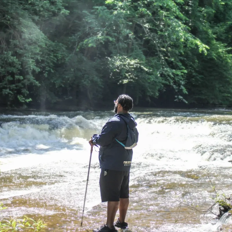
    Hiking at Burgess Falls

    Burgess Falls has several adventurous hiking trails ranging from moderate to strenuous.

    The hikes provide ample opportunities to see the four waterfalls on the Falling Water River.  

    Window Cliffs Must-Know Information

    The following information will help make your trip more successful and enjoyable.  
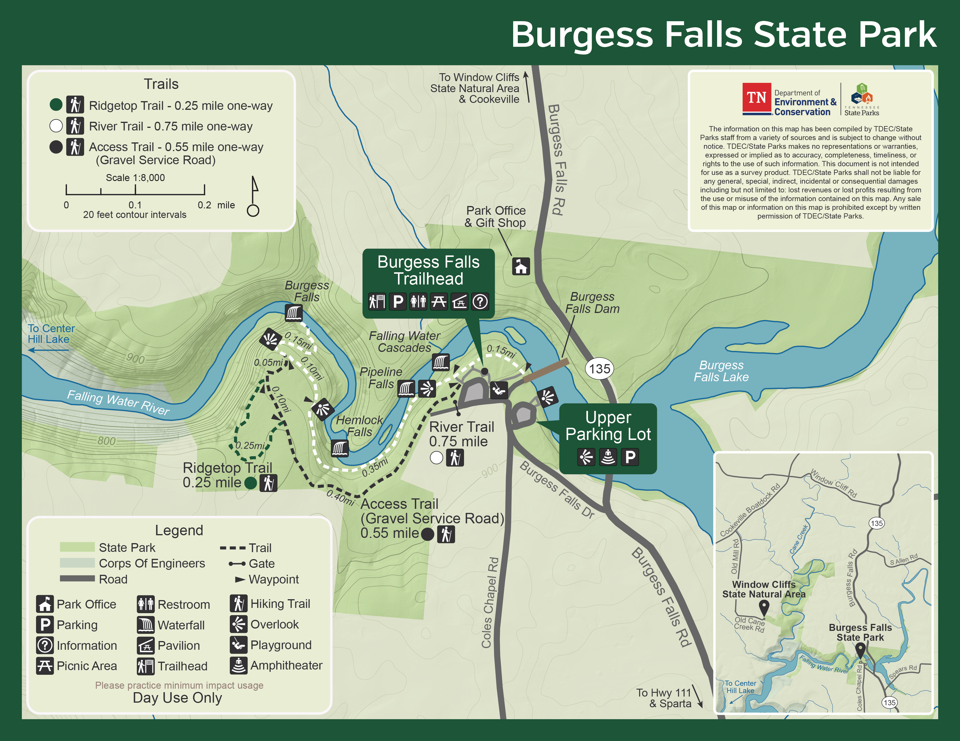
    • Creek Crossings Challenge

      A round trip requires 18 creek crossings which can be challenging or impassable during high water as there are no bridges, only cables and rock crossings. Water can, at times, begin to rise in the creek unexpectedly due to rain in the watershed.  

    • Closures

      There will be times that the area is closed due to high water. Always check the weather reports before heading out.  

    • Pack Light

      The less you take on the hike, the better. It is best to limit belongings to items that will fit in a small backpack. Keep your hands free.  

    • Proper Footwear

      Wear sturdy shoes that can get wet. Flip-flops are not recommended.  

    • Pet Policy

      Pets are not allowed within Window Cliffs State Natural Area for safety reasons.  

    • Camping

      No camping is allowed. However, cabins and camping are offered at Standing Stone State Park, Rock Island State Park, and Edgar Evins State Park.  

    Trails

    Showing page 1 of 1
    • Access Trail (Gravel Service Road)

      Burgess Falls State Park
      Distance
      0.55 mi.
      Difficulty
      Surface
      gravel
      Availability
      Open
      Allowed
      Hiking

      Ridgetop Trail

      Burgess Falls State Park
      Distance
      0.25 mi.
      Difficulty
      Difficult
      Surface
      Natural
      The Ridge Top Trail is scenic with beautiful views down the main canyon of the Falling Water River.
      Availability
      Open
      Allowed
      Hiking

      Ridgetop Trail

      Burgess Falls State Park
      The Ridge Top Trail is scenic with beautiful views down the main canyon of the Falling Water River.
      Distance
      0.25 mi.
      Difficulty
      Difficult
      Surface
      Natural
      Allowed
      Hiking

      Trail Type
      Information unavailable

      Elevation
      Gain 17.50'
      Loss 44.40'
      Grade
      Typical 4.1%
      Max 23.6%
      Cross Slope
      Typical 1.6%
      Max 7.0%
      Tread Width
      Typical 37"
      Minimum 12"
      Surface Type
      Soil 92.1%; Gravel 5.6%; Wood decking 2.3%
      Obstructions Exist
      Step: 9 in tall; Tree root: 9 in tall; Tree root: 6 in tall

      River Trail

      Burgess Falls State Park
      Distance
      0.75 mi.
      Difficulty
      Difficult
      Surface
      Natural
      The 1.5-mile round-trip River Trail Service Road Loop is a moderately strenuous hike taking visitors past four waterfalls on the Falling Water River. The waterfalls are 20' cascades, 30' upper falls, 80' middle falls, and 136' lower falls in height. Most people prefer to hike back to the parking lot along the service road.
      Availability
      Open
      Allowed
      Hiking

      River Trail

      Burgess Falls State Park
      The 1.5-mile round-trip River Trail Service Road Loop is a moderately strenuous hike taking visitors past four waterfalls on the Falling Water River. The waterfalls are 20' cascades, 30' upper falls, 80' middle falls, and 136' lower falls in height. Most people prefer to hike back to the parking lot along the service road.
      Distance
      0.75 mi.
      Difficulty
      Difficult
      Surface
      Natural
      Allowed
      Hiking

      Trail Type
      Information unavailable

      Elevation
      Gain 90.80'
      Loss 52.80'
      Grade
      Typical 5.2%
      Max 23.3%
      Cross Slope
      Typical 3.0%
      Max 13.0%
      Tread Width
      Typical 38"
      Minimum 12"
      Surface Type
      Soil 88.9%; Wood decking 4.7%; Concrete 3.9%; Gravel 2.5%
      Obstructions Exist
      Step: 15 in tall; Tree: 24 in of tread remaining; Tree: 24 in of tread remaining

    Trail Definitions

    • Cross Slope 

      Describes the degree of incline from one side of the trail path to the other; measured as a percentage. Cross slope aids in water drainage and impacts the overall trail stability.   

    • Grade  

      Describes the rise in elevation over a horizontal distance on the trail; measured as a percentage.  Higher percentages represent a steeper grade indicating a more challenging ascent or descent for hikers.    

    • Standard Ramp Grade

      Serves as a reference guide for the grade of the trail.  Standard Ramp Grade is 8.3% across all trail assessments.  

    • Surface 

      A characteristic of the trail expressed in terms of material type, grading, compaction, and roughness of the path. Possible surface types include soil, gravel, paved, and mulch.   

    • Tread Width    

      Represents the horizontal distance from one edge of the trail path to the other; measurements can vary.  Tread width helps to determine the amount of space a hiker has to pass through. Obstacles on the trail can alter the remaining tread width.   

    • Trail Types: Loop

      Trail returns at or near the point from which you started. 

    • Trail Types: Network 

      Offers multiple route options within one trail, and each route is connected

    • Trail Types: Out and Back

      This type of trail travels out to an endpoint where hikers turn around and travel back to the starting point.   

    • Trail Types: Stacked Loop

      A loop trail contained completely within another trail.   

    Need a Map?

    Explore our collection of printable and digital trail maps, organized by park. Whether you’re hiking, camping, or paddling, you’ll find the resources you need to navigate confidently.


    Skip photo gallery
    Media Crowdriff

    Visitor Center Gift Shop

    The Visitor Center Gift Shop is the perfect place to pick up a map, learn about the park, or find a souvenir. You’ll find an assortment of apparel and keepsakes to remember your trip to the park.

    Address:
    8487 Burgess Falls Road, Baxter TN, 38544
    1-931-432-5312

    Hours: 8:00 AM - 4:00 PM

    Happenings

    No events are scheduled at this time, but there's always more to explore.

    Find More Events

    Other Activities at Burgess Falls State Park