Rocky Fork Hiking

  • Wooden bridge over a stream, surrounded by lush greenery.
  • Wooden bridge over a clear stream, surrounded by colorful autumn trees.

    Hiking at Rocky Fork

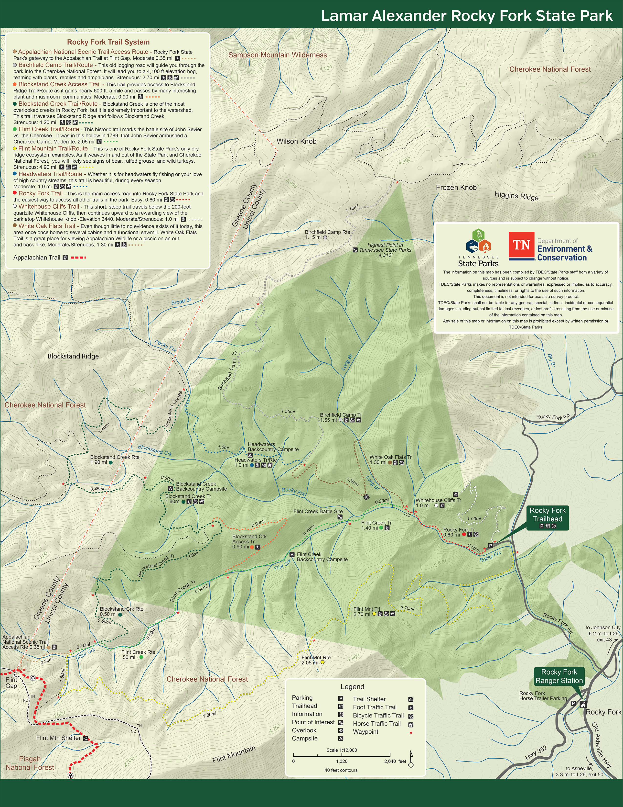
    Nearly 20 miles of marked trails within the boundary of the state park provide great views of our Southern Appalachian Forest, and a direct access to the Appalachian Trail. 

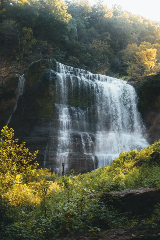
    Ranging from easy to strenuous, Rocky Fork trails offer the highest elevation overlook in any Tennessee State Park, opportunity to see ruffed grouse and bear, and discover numerous cascades and waterfalls 

    Ranger-led guided hikes through the forest are recommended and offered throughout the year. Be sure to wear sturdy hiking boots and comfortable outdoor clothing. Weather can change abruptly in the mountains, so be prepared. 

    Trails

    Showing page 1 of 2
    • Appalachian National Scenic Trail Access Route

      Rocky Fork State Park
      Distance
      0.35 mi.
      Difficulty
      Moderate
      Surface
      Natural
      Rocky Fork State Park's gateway to the Appalachian Trail at Flint Gap.
      Availability
      Open
      Allowed
      Hiking

      Birchfield Camp Trail/Route

      Rocky Fork State Park
      Distance
      2.70 mi.
      Difficulty
      Difficult
      Surface
      Natural
      This old logging road will guide you through the park into the Cherokee National Forest. It will lead you to a 4,100 ft elevation bog, teaming with plants, reptiles and amphibians.
      Availability
      Open
      Allowed
      Hiking Horseback Riding Mountain Biking

      Blockstand Creek Access Trail

      Rocky Fork State Park
      Distance
      0.90 mi.
      Difficulty
      Moderate
      Surface
      Natural
      This trail provides access to Blockstand Ridge Trail/Route as it gains nearly 600 ft. a mile and passes by many interesting plant and mushroom communities.
      Availability
      Open
      Allowed
      Hiking

      Blockstand Creek Trail

      Rocky Fork State Park
      Distance
      Difficulty
      Surface
      Natural
      Availability
      Open
      Allowed
      Hiking

      Blockstand Creek Trail/Route

      Rocky Fork State Park
      Distance
      4.20 mi.
      Difficulty
      Difficult
      Surface
      Natural
      Blockstand Creek is one of the most overlooked creeks in Rocky Fork, but it is extremely important to the watershed. This trail traverses Blockstand Ridge and follows Blockstand Creek.
      Availability
      Open
      Allowed
      Hiking Horseback Riding Mountain Biking

      Flint Creek Trail/Route

      Rocky Fork State Park
      Distance
      2.05 mi.
      Difficulty
      Moderate
      Surface
      Natural
      This historic trail marks the battle site of John Sevier vs. the Cherokee. It was in this hollow in 1789, that John Sevier ambushed a Cherokee Camp.
      Availability
      Open
      Allowed
      Hiking

      Flint Mountain Trail/Route

      Rocky Fork State Park
      Distance
      4.90 mi.
      Difficulty
      Difficult
      Surface
      Natural
      This is one of Rocky Fork State Park's only dry ridge ecosystem examples. As it weaves in and out of the State Park and Cherokee National Forest, you will likely see signs of bear, ruffed grouse, and wild turkeys.
      Availability
      Open
      Allowed
      Hiking Horseback Riding Mountain Biking

      Headwaters Trail/Route

      Rocky Fork State Park
      Distance
      1.00 mi.
      Difficulty
      Moderate
      Surface
      Natural
      Whether it is for headwaters fly fishing or your love of high country streams, this trail is beautiful, during every season.
      Availability
      Open
      Allowed
      Hiking Horseback Riding Mountain Biking

      Rocky Fork Trail

      Rocky Fork State Park
      Distance
      0.60 mi.
      Difficulty
      Difficult
      Surface
      Natural
      This is the main access road into Rocky Fork State Park and the easiest way to access all other trails in the park.
      Availability
      Open
      Allowed
      Hiking Mountain Biking

      Rocky Fork Trail

      Rocky Fork State Park
      This is the main access road into Rocky Fork State Park and the easiest way to access all other trails in the park.
      Distance
      0.60 mi.
      Difficulty
      Difficult
      Surface
      Natural
      Allowed
      Hiking Mountain Biking

      Trail Type
      Information unavailable

      Elevation
      Gain 144.70'
      Loss 6.10'
      Grade
      Typical 5.3%
      Max 17.5%
      Cross Slope
      Typical 2.2%
      Max 11.3%
      Tread Width
      Typical 91"
      Minimum 48"
      Surface Type
      Gravel 94.8%; Rock 3.2%; Soil 2%
      Obstructions Exist
      Rocks: 4 in tall
    • White Oak Flats Trail

      Rocky Fork State Park
      Distance
      1.30 mi.
      Difficulty
      Moderate
      Surface
      Natural
      Even though little to no evidence exists of it today, this area was once home to several cabins and a functional sawmill. White Oak Flats Trail is a great place for viewing Appalachian Wildlife or a picnic on an out and back hike.
      Availability
      Open
      Allowed
      Hiking Mountain Biking

      Whitehouse Cliffs Trail

      Rocky Fork State Park
      Distance
      1.00 mi.
      Difficulty
      Moderate
      Surface
      Natural
      This short, steep trail travels below the 200-foot quartzite Whitehouse Cliffs, then continues upward to a rewarding view of the park atop Whitehouse Knob.-Elevation 3440'.
      Availability
      Open
      Allowed
      Hiking

    Trail Definitions

    • Cross Slope 

      Describes the degree of incline from one side of the trail path to the other; measured as a percentage. Cross slope aids in water drainage and impacts the overall trail stability.   

    • Grade  

      Describes the rise in elevation over a horizontal distance on the trail; measured as a percentage.  Higher percentages represent a steeper grade indicating a more challenging ascent or descent for hikers.    

    • Standard Ramp Grade

      Serves as a reference guide for the grade of the trail.  Standard Ramp Grade is 8.3% across all trail assessments.  

    • Surface 

      A characteristic of the trail expressed in terms of material type, grading, compaction, and roughness of the path. Possible surface types include soil, gravel, paved, and mulch.   

    • Tread Width    

      Represents the horizontal distance from one edge of the trail path to the other; measurements can vary.  Tread width helps to determine the amount of space a hiker has to pass through. Obstacles on the trail can alter the remaining tread width.   

    • Trail Types: Loop

      Trail returns at or near the point from which you started. 

    • Trail Types: Network 

      Offers multiple route options within one trail, and each route is connected

    • Trail Types: Out and Back

      This type of trail travels out to an endpoint where hikers turn around and travel back to the starting point.   

    • Trail Types: Stacked Loop

      A loop trail contained completely within another trail.   

    Need a Map?

    Explore our collection of printable and digital trail maps, organized by park. Whether you’re hiking, camping, or paddling, you’ll find the resources you need to navigate confidently.


    Recreation Area Safety

    As with any primitive recreation area, caution should be exercised when visiting the park.  

    • Do Not Approach Wildlife

      In the event that you see a bear in the backcountry, do not approach the bear or throw food to the bear.  

    • Keep Pets Leashed

      For the safety of your pet and for the safety of park wildlife, keep your pets leashed at all times.

    • Be Familiar With Navigating

      If hiking in the forest, it is recommended that hikers have familiarity with the area and experience with backcountry navigating and familiarity with GPS, compass, and maps. 

    Ranger Station Gift Shop

    The Rocky Fork Ranger Station Gift Shop is the perfect place to pick up a map, learn about the park, or find a souvenir. You’ll find an assortment of apparel and keepsakes to remember your trip to the park.

    Address:
    280 Jennie Moore Rd, Flag Pond TN, 37657

    Hours
    Seasonal

    Skip photo gallery
    Media Crowdriff
    Happenings

    No events are scheduled at this time, but there's always more to explore.

    Find More Events

    Other Activities at Rocky Fork State Park