Cummins Falls Hiking

Warning Alert
Warning

Before You Visit Cummins Falls

Cummins Falls State Park

A Gorge Access Permit is required to visit the base of the waterfall. The base of the waterfall is only accessible on fair-weather days. 

Cummins Falls is a natural area with inherent safety risks.

  • The gorge is prone to flash flooding.
    • Changes in water levels in the gorge can result in the sudden closure of trail access to the base of the falls.
    • Rain can significantly affect the amount of water over the falls, so visitors are encouraged to check the weather forecast in the days leading up to their visit. Even if it isn't raining at the park, rain upstream can raise water levels in a matter of minutes. 
  • Please remain aware of your surroundings during your visit, and exit the base if you notice water volume increasing.

You should comply with the park’s safety instructions. We recommend that children 5 and under not go to the falls. Children 12 and under must wear life vests at falls and be accompanied by an adult.

Visiting the gorge is a very strenuous, physically demanding activity. Visiting the waterfall will require:

  • Strenuous Hiking
  • Swimming or wading through water
  • Climbing Rocks
  • Crossing Slippery Rocks

For the most up-to-date information, please check the Cummins Falls State Park Facebook page. On-site park staff will post photos and trail closure alerts on that page. 

Notification

Accessibility Road Under Maintenance

Cummins Falls State Park

Due to maintenance, our accessible parking at the Waterfall Overlook has restricted access.  However, our all-terrain wheelchairs are still operational for those who would like to put in a request either online or on a first-come basis onsite.  We apologize for the inconvenience.

  • Waterfall cascading over rocky cliffs surrounded by trees.
  • mossy green trail

    Hiking at Cummins Falls

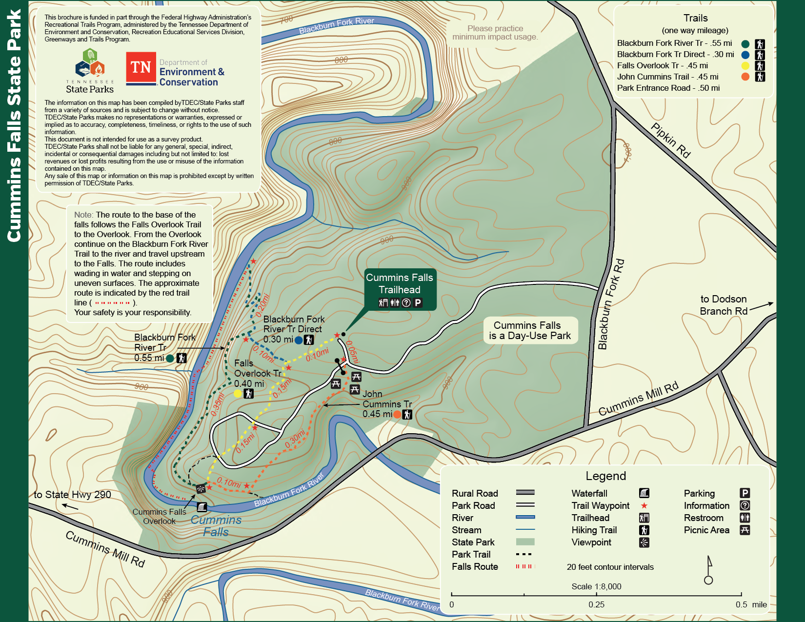
    Cummins Falls State Park offers several adventurous hiking trails ranging from moderate to difficult. The route descending into the gorge, also known as the trail through the riverway to the base of the falls, requires a permit. Several other trails do not require a permit and are more accessible.

    Trails

    Showing page 1 of 2
    • Access Road

      Cummins Falls State Park
      Distance
      0.65 mi.
      Difficulty
      Surface
      gravel
      Availability
      Open
      Allowed
      Hiking all_terrain_wheelchair

      Blackburn Fork River Trail

      Cummins Falls State Park
      Distance
      0.35 mi.
      Difficulty
      Surface
      Natural
      Trail along edge of bluff above Blackburn Fork River to waterfall overlook.
      Availability
      Open
      Allowed
      Hiking

      Blackburn Fork River Trail Direct

      Cummins Falls State Park
      Distance
      0.30 mi.
      Difficulty
      Surface
      Natural
      Availability
      Open
      Allowed
      Hiking

      Delia Bell Access Road

      Cummins Falls State Park
      Distance
      Difficulty
      Surface
      Natural
      Availability
      Open
      Allowed
      Hiking

      Dow Burgess Loop Trail

      Cummins Falls State Park
      Distance
      0.75 mi.
      Difficulty
      Surface
      Natural
      Availability
      Open
      Allowed
      Hiking

      Falls Overlook Trail

      Cummins Falls State Park
      Distance
      0.35 mi.
      Difficulty
      Difficult
      Surface
      Mixed

      The parks most popular feature is Cummins Falls at 75’ tall. The waterfall can be viewed at the end of the Falls Overlook Trail from an accessible overlook on top of the bluff overlooking the gorge. 

      Wheelchair accessible: both non-electric and all-terrain wheelchairs. Visitors with wheelchairs can drive down the access road, park in designated wheelchair-accessible parking and use the concrete trail leading from the parking space to the overlook to enjoy a view of the waterfall.  

      Availability
      Open
      Allowed
      Hiking all_terrain_wheelchair

      Falls Overlook Trail

      Cummins Falls State Park

      The parks most popular feature is Cummins Falls at 75’ tall. The waterfall can be viewed at the end of the Falls Overlook Trail from an accessible overlook on top of the bluff overlooking the gorge. 

      Wheelchair accessible: both non-electric and all-terrain wheelchairs. Visitors with wheelchairs can drive down the access road, park in designated wheelchair-accessible parking and use the concrete trail leading from the parking space to the overlook to enjoy a view of the waterfall.  

      Distance
      0.35 mi.
      Difficulty
      Difficult
      Surface
      Mixed
      Allowed
      Hiking all_terrain_wheelchair

      Trail Type
      Information unavailable

      Elevation
      Gain 29.40'
      Loss 92.20'
      Grade
      Typical 5.4%
      Max 26.2%
      Cross Slope
      Typical 5.1%
      Max 16.4%
      Tread Width
      Typical 60"
      Minimum 36"
      Surface Type
      Soil 86.9%; Gravel 71%; Concrete 6%
      Obstructions Exist
      Tree root: 4 in tall; Step: 3 in tall; Post: 36 in of tread remaining

      Gorge Access Route

      Cummins Falls State Park
      Distance
      0.50 mi.
      Difficulty
      Surface
      riverbed
      Availability
      Open
      Allowed
      Hiking

      John Cummins Trail

      Cummins Falls State Park
      Distance
      0.45 mi.
      Difficulty
      Difficult
      Surface
      Natural
      Similar distance to Falls Overlook Trail begins at picnic area.
      Availability
      Open
      Allowed
      Hiking

      John Cummins Trail

      Cummins Falls State Park
      Similar distance to Falls Overlook Trail begins at picnic area.
      Distance
      0.45 mi.
      Difficulty
      Difficult
      Surface
      Natural
      Allowed
      Hiking

      Trail Type
      Information unavailable

      Elevation
      Gain 48.30'
      Loss 131.10'
      Grade
      Typical 8.6%
      Max 34.7%
      Cross Slope
      Typical 2.8%
      Max 14.7%
      Tread Width
      Typical 36"
      Minimum 12"
      Surface Type
      Soil 95.3%; Gravel 4.7%
      Obstructions Exist
      Tree root: 6 in tall; Tree root: 4 in tall; Tree stump: 24 in of tread remaining

      Lou Garrison Loop Trail

      Cummins Falls State Park
      Distance
      0.35 mi.
      Difficulty
      Easy
      Surface
      Natural
      Availability
      Open
      Allowed
      Hiking
    • Low Gap Trail

      Cummins Falls State Park
      Distance
      1.15 mi.
      Difficulty
      Easy
      Surface
      Natural
      Availability
      Open
      Allowed
      Hiking

      Storybook Trail

      Cummins Falls State Park
      Distance
      0.35 mi.
      Difficulty
      Difficult
      Surface
      Natural
      Availability
      Open
      Allowed
      Hiking

      Storybook Trail

      Cummins Falls State Park
      Distance
      0.35 mi.
      Difficulty
      Difficult
      Surface
      Natural
      Allowed
      Hiking

      Trail Type
      Information unavailable

      Elevation
      Gain 34.60'
      Loss 42.40'
      Grade
      Typical 4.0%
      Max 25.0%
      Cross Slope
      Typical 4.3%
      Max 14.0%
      Tread Width
      Typical 30"
      Minimum 24"
      Surface Type
      Soil 100%
      Obstructions Exist
      Tree root: 5 in tall; Tree stump: 12 in of tread remaining; Tree root: 4 in tall

    Safety Tips

    • 1

      Precautions When Hiking at Cummins Falls

      This informative video is an easy way to learn many of the key safety precautions you must follow when hiking at Cummins Falls.  

      Watch This (Opens in a new tab)
    • 2

      Gorge Access Permits Required 

      The park now offers gorge access permits that are required for any visitor wishing to enter the gorge or visit the base of the waterfall. The gorge is the trail through the river way. You can purchase permits online or at the park visitor center. Due to the limited daily quantity of permits, we recommend purchasing your permit online in advance. Please note: No refunds, exchanges, date transfers, or rain checks will be issued for permits.  

    • 3

      Bring your own personal floatation device or life jacket.

      There is a limited number of jackets available at the park for both adults and children. 

    Trail Definitions

    • Cross Slope 

      Describes the degree of incline from one side of the trail path to the other; measured as a percentage. Cross slope aids in water drainage and impacts the overall trail stability.   

    • Grade  

      Describes the rise in elevation over a horizontal distance on the trail; measured as a percentage.  Higher percentages represent a steeper grade indicating a more challenging ascent or descent for hikers.    

    • Standard Ramp Grade

      Serves as a reference guide for the grade of the trail.  Standard Ramp Grade is 8.3% across all trail assessments.  

    • Surface 

      A characteristic of the trail expressed in terms of material type, grading, compaction, and roughness of the path. Possible surface types include soil, gravel, paved, and mulch.   

    • Tread Width    

      Represents the horizontal distance from one edge of the trail path to the other; measurements can vary.  Tread width helps to determine the amount of space a hiker has to pass through. Obstacles on the trail can alter the remaining tread width.   

    • Trail Types: Loop

      Trail returns at or near the point from which you started. 

    • Trail Types: Network 

      Offers multiple route options within one trail, and each route is connected

    • Trail Types: Out and Back

      This type of trail travels out to an endpoint where hikers turn around and travel back to the starting point.   

    • Trail Types: Stacked Loop

      A loop trail contained completely within another trail.   

    Permits and Inherent Hazards

      • Cascading waterfall with surrounding cliffs and rocky riverbed.

      Trails Requiring Permits

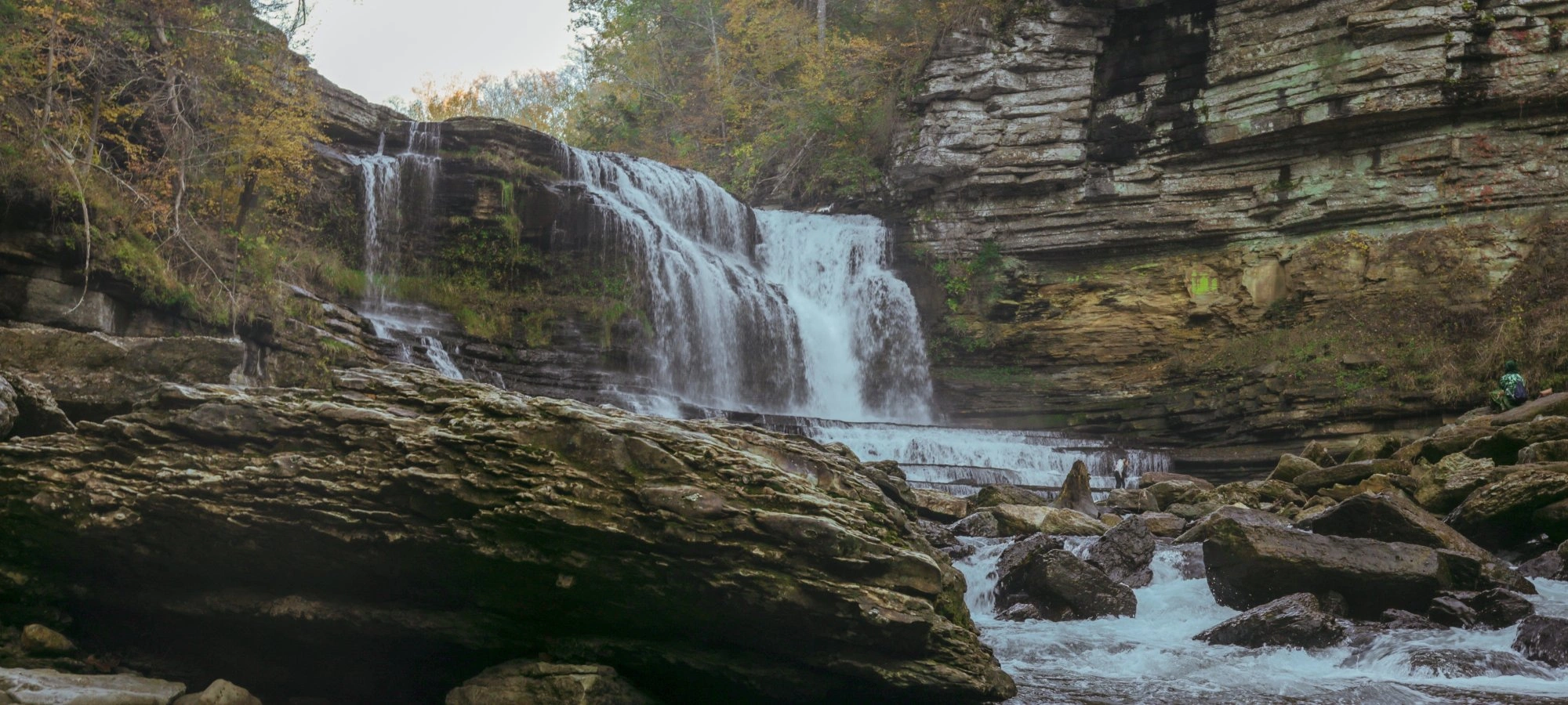
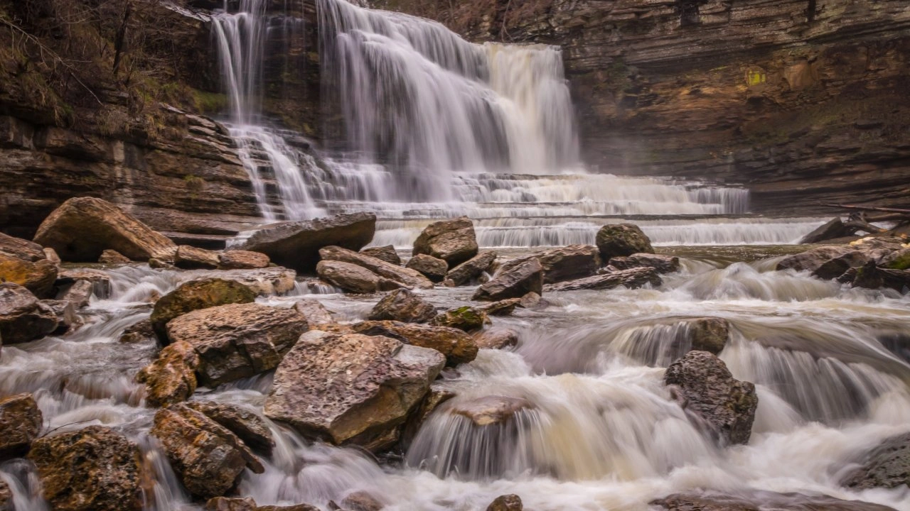
      The park has a trail that runs through the gorge to the base of the waterfall. Trail routes to the gorge, through the gorge, and to the base of the waterfall are rugged and steep with uneven terrain. They have significant elevation drops and include walking along the rocky riverbed. Natural trail surfaces are varied and include water crossings, boulders and other obstacles. These are not improved trails.  

      • Shortcut to Downstream
      • Downstream Trail 
      • Waterfall cascading over rocky ledges with surrounding cliffs.

      Inherent Hazards

      The gorge is a natural feature unaltered by man, as is most of the park. There are inherent hazards. While very beautiful, this is a rugged area. For this reason, follow safety advice and guidance as you enjoy your time in the park.  

    Precautions

    Follow these precautions in order to remain safe and prevent injuries.  

    • No Small Children

      The hike to the gorge is not an improved trail. This is an adventurous hike and is not suitable for small children. 

    • Life Jackets

      USCG-approved life jackets are advised if you plan to get in the water below the falls. While some life jackets are available at the park, we recommend bringing your own. Those 12 and under are required to wear life jackets.

    • Keep Carry-In Items Simple

      The less you take to the bottom of the waterfall, the better. It is best to limit belongings to items that will fit in a small backpack. Keep your hands free.

    • Wear Proper Footwear

      Wear sturdy shoes. Flip-flops are not recommended.  

    • Eat Before Hiking

      Rather than try to take a picnic to the gorge area, plan to eat in the designated picnic area and just take snacks and water to the gorge.  

    • No Alcoholic Beverages

      Alcoholic beverages are not allowed in the park.  

    Prohibited Items

    The following items are prohibited. Do not bring them along on your hike. Please leave them in your vehicle.  

    • Coolers
    • Glass
    • Strollers
    • Alcohol
    • Pool floats (except for life jackets) 
    • Serene forest reflected in a calm river under a clear blue sky.

    Need a Map?

    Explore our collection of printable and digital trail maps, organized by park. Whether you’re hiking, camping, or paddling, you’ll find the resources you need to navigate confidently.


    Nearby Camping

    No camping is allowed at Cummins Falls; however, cabins and camping are offered at Standing Stone State Park and Edgar Evins State Park

    Standing Stone State Park is a 40-minute drive (23 miles) from the park and offers cabins and tent and trailer camping year-round. 

    Edgar Evins State Park is a 35-minute drive (27 miles) from the park and offers seasonal tent and trailer camping and condo-style cabins year-round. 

    Old Mill Camp, located across from our entrance offers RV camping and cottage rentals. They can be reached at 1-931-268-0045 or oldmillcamp.com. 

    Twin Lakes Catfish Farm in Baxter offers RV and a few tent sites. Call 1-931-858-2333 for more info. 

    Nearby Cookeville offers a variety of lodging options.

    Visitor Center Gift Shop

    The Visitor Center Gift Shop is the perfect place to pick up a map, learn about the park, or find a souvenir. You’ll find an assortment of apparel and keepsakes to remember your trip to the park.

    Address:
    390 Cummins Falls Lane, Cookeville TN, 38501
    1-931-268-7223

    Hours
    8:00 AM - 6:00 PM

    Skip photo gallery
    Media Crowdriff
    Happenings

    No events are scheduled at this time, but there's always more to explore.

    Find More Events