Johnsonville Hiking

  • A snow-covered path winds through a forest, flanked by a rustic wooden fence. Bare trees and scattered brown leaves create a serene, wintry atmosphere.
  • A person wearing hiking boots and green pants sits on a wooded trail. A red water bottle with a nature design is placed beside them, surrounded by fallen leaves.

    Hiking at Johnsonville State Park  

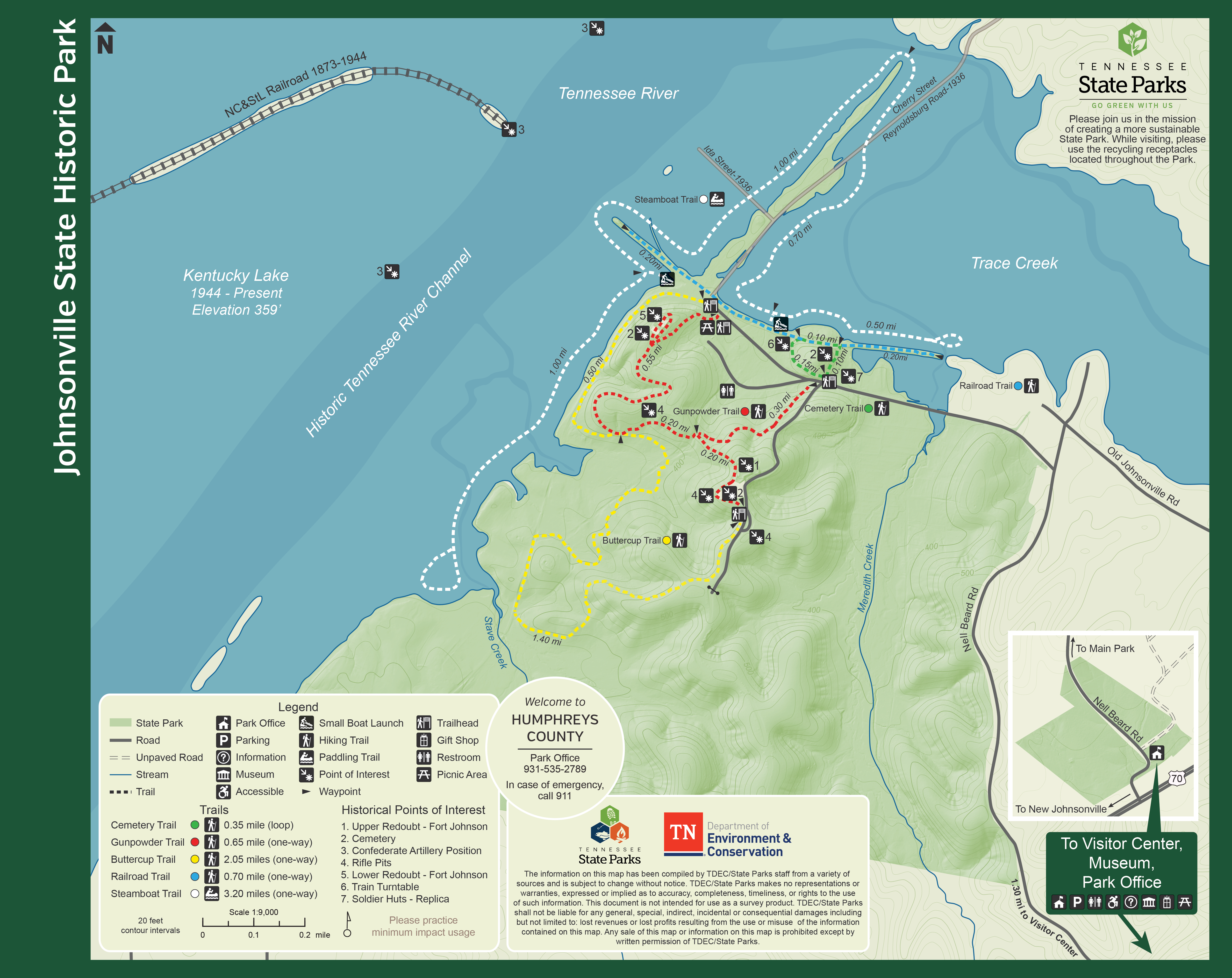
    Take a hike to explore how rivers, railroads, and raiders shaped the stories of Johnsonville. Grab a map from the Visitor Center or at the trailhead to guide your adventure.

    The Gunpowder Trail is a 0.65-mile path that travels through several historical points, including a few rifle pits and the remnants of Fort Johnson. 

    Located directly next to the Gunpowder Trail lies the Buttercup Trail. This trail is just over two miles and covers much of the park, offering scenic views of the Tennessee River.

    Take the Cemetery Trail to view more of the cemetery and the train turntable. This 0.35-mile loop features a replica of the soldiers' huts and leads into the Railroad Trail.

    The Railroad Trail features an old railroad bed following the shores of Trace Creek and the Tennessee River.

    Trails

    Showing page 1 of 1
    • Buttercup Trail

      Johnsonville State Historic Park
      Distance
      2.05 mi.
      Difficulty
      Difficult
      Surface
      Natural
      This trail passes through mature forest and skirts along the Tennessee River bank.
      Availability
      Open Seasonal
      Allowed
      Hiking

      Buttercup Trail

      Johnsonville State Historic Park
      This trail passes through mature forest and skirts along the Tennessee River bank.
      Distance
      2.05 mi.
      Difficulty
      Difficult
      Surface
      Natural
      Allowed
      Hiking

      Trail Type
      Information unavailable

      Elevation
      Gain 118.60'
      Loss 335.70'
      Grade
      Typical 4.5%
      Max 27.2%
      Cross Slope
      Typical 5.7%
      Max 20.8%
      Tread Width
      Typical 46"
      Minimum 12"
      Surface Type
      Soil 89.6%; Asphalt 6.8%; Gravel 3.6%
      Obstructions Exist
      Drainage dip: 6 in deep; Hole: 24 in of tread remaining; Erosion: 12 in of tread remaining

      Cemetery Trail

      Johnsonville State Historic Park
      Distance
      0.35 mi.
      Difficulty
      Difficult
      Surface
      Paved
      Take the Cemetery Trail to view more of the cemetery and the train turntable. This 0.35-mile loop features a replica of the soldiers' huts and leads into the Railroad Trail.
      Availability
      Open
      Allowed
      Hiking

      Cemetery Trail

      Johnsonville State Historic Park
      Take the Cemetery Trail to view more of the cemetery and the train turntable. This 0.35-mile loop features a replica of the soldiers' huts and leads into the Railroad Trail.
      Distance
      0.35 mi.
      Difficulty
      Difficult
      Surface
      Paved
      Allowed
      Hiking

      Trail Type
      Information unavailable

      Elevation
      Gain 25.40'
      Loss 41.10'
      Grade
      Typical 4.3%
      Max 17.3%
      Cross Slope
      Typical 5.8%
      Max 19.5%
      Tread Width
      Typical 63"
      Minimum 24"
      Surface Type
      Soil 55.2%; Gravel 40.1%; Asphalt 4.7%
      Obstructions Exist
      Tree root: 8 in tall; Staircase: 4 in tall

      Gunpowder Trail

      Johnsonville State Historic Park
      Distance
      0.65 mi.
      Difficulty
      Difficult
      Surface
      Natural
      This trail has quite a few gains in elevation but you can see historic rifle pits along the way.
      Availability
      Open Seasonal
      Allowed
      Hiking

      Gunpowder Trail

      Johnsonville State Historic Park
      This trail has quite a few gains in elevation but you can see historic rifle pits along the way.
      Distance
      0.65 mi.
      Difficulty
      Difficult
      Surface
      Natural
      Allowed
      Hiking

      Trail Type
      Information unavailable

      Elevation
      Gain 196.50'
      Loss 345.40'
      Grade
      Typical 7.1%
      Max 32.3%
      Cross Slope
      Typical 7.1%
      Max 25.7%
      Tread Width
      Typical 51"
      Minimum 24"
      Surface Type
      Soil 61.5%; Gravel 37.7%; Mulch 6.2%
      Obstructions Exist
      Dip: 6 in deep; Tree root: 6 in tall; Tree root: 6 in tall

      Railroad Trail

      Johnsonville State Historic Park
      Distance
      0.70 mi.
      Difficulty
      Difficult
      Surface
      Natural
      Take the Cemetery Trail to view more of the cemetery and the train turntable. This 0.35-mile loop features a replica of the soldiers' huts and leads into the Railroad Trail.
      Availability
      Open
      Allowed
      Hiking

      Railroad Trail

      Johnsonville State Historic Park
      Take the Cemetery Trail to view more of the cemetery and the train turntable. This 0.35-mile loop features a replica of the soldiers' huts and leads into the Railroad Trail.
      Distance
      0.70 mi.
      Difficulty
      Difficult
      Surface
      Natural
      Allowed
      Hiking

      Trail Type
      Information unavailable

      Elevation
      Gain 34.20'
      Loss 45.10'
      Grade
      Typical 2.2%
      Max 31.1%
      Cross Slope
      Typical 2.8%
      Max 12.2%
      Tread Width
      Typical 88"
      Minimum 48"
      Surface Type
      Soil 63.9%; Gravel 36.1%
      Obstructions Exist
      Tree roots: 3 in tall; Tree root: 3 in tall

      Steamboat Trail

      Johnsonville State Historic Park
      Distance
      3.20 mi.
      Difficulty
      Surface
      Water
      Availability
      Open
      Allowed
      paddle

    Trail Definitions

    • Cross Slope 

      Describes the degree of incline from one side of the trail path to the other; measured as a percentage. Cross slope aids in water drainage and impacts the overall trail stability.   

    • Grade  

      Describes the rise in elevation over a horizontal distance on the trail; measured as a percentage.  Higher percentages represent a steeper grade indicating a more challenging ascent or descent for hikers.    

    • Standard Ramp Grade

      Serves as a reference guide for the grade of the trail.  Standard Ramp Grade is 8.3% across all trail assessments.  

    • Surface 

      A characteristic of the trail expressed in terms of material type, grading, compaction, and roughness of the path. Possible surface types include soil, gravel, paved, and mulch.   

    • Tread Width    

      Represents the horizontal distance from one edge of the trail path to the other; measurements can vary.  Tread width helps to determine the amount of space a hiker has to pass through. Obstacles on the trail can alter the remaining tread width.   

    • Trail Types: Loop

      Trail returns at or near the point from which you started. 

    • Trail Types: Network 

      Offers multiple route options within one trail, and each route is connected

    • Trail Types: Out and Back

      This type of trail travels out to an endpoint where hikers turn around and travel back to the starting point.   

    • Trail Types: Stacked Loop

      A loop trail contained completely within another trail.   

    Need a Map?

    Explore our collection of printable and digital trail maps, organized by park. Whether you’re hiking, camping, or paddling, you’ll find the resources you need to navigate confidently.


    Visitor Center Gift Shop

    The Visitor Center Gift Shop is the perfect place to pick up a map, learn about the park, or find a souvenir. You’ll find an assortment of apparel and keepsakes to remember your trip to the park.

    Address:
    90 Nell Beard Road, New Johnsonville TN, 37134
    1-931-535-2789

    Hours: 
    Seasonal. Please call for more information.

    Skip photo gallery
    Media Crowdriff
    Happenings

    No events are scheduled at this time, but there's always more to explore.

    Find More Events

    Other Activities at Johnsonville State Historic Park