Radnor Lake Hiking

Notification Alert
Notification

EV Chargers Temporarily Unavailable

Radnor Lake State Park

Due to pending upgrades of the Electric Vehicle Chargers at Radnor Lake State Park, the current chargers are temporarily unavailable.

Thank you for your patience and understanding. If you have any questions, please contact our park office.

  • Child in a motorized wheelchair exploring the forest with two adults.
  • large orange leaved tree hanging over the multch path

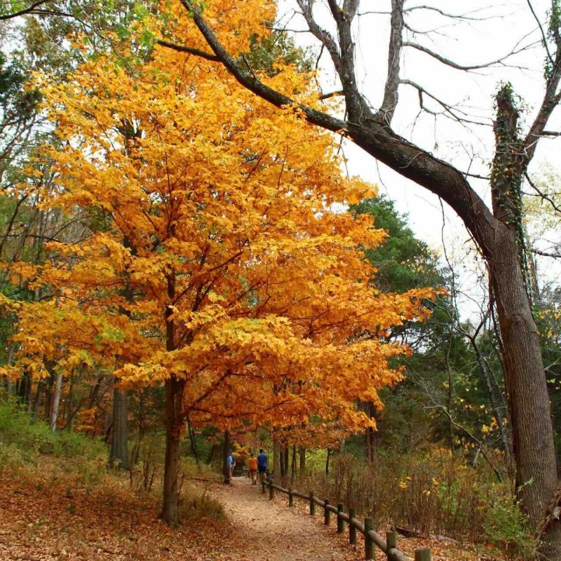
    Hiking at Radnor Lake

    Radnor Lake State Park is day-use only and is protected as a Class II Natural Area, so the trails are strictly used for hiking and wildlife observation.

    Pets, jogging, and bicycles are only allowed on Otter Creek Road and the gravel road on the dam. Trails are open daily from 6:00 AM until 20 minutes after sunset.

    Radnor Lake State Park has some of the highest hills in the Nashville Basin. Wildlife is amazingly abundant. One can observe geese, herons, coots, and other birds as well as many species of salamanders, frogs, snakes, lizards, turtles, and mammals. Hundreds of species of wildflowers, mosses, fungi, ferns, and other lesser plants, as well as trees, shrubs, and vines, add to the natural ecological diversity of the area.

    Trails

    Showing page 1 of 2
    • Access Trail

      Radnor Lake State Park
      Distance
      0.25 mi.
      Difficulty
      Moderate
      Surface
      Natural
      This short mulched trail provides a quick link from the east parking area to the Ganier Ridge Trail. Hikers can also use this trail for access to the nearby Lake Trail.
      Availability
      Open
      Allowed
      Hiking

      Dam Walkway

      Radnor Lake State Park
      Distance
      0.20 mi.
      Difficulty
      Easy
      Surface
      gravel
      This gravel trail is the shortest in the park. It provides a gentle, flat surface across the Dam Walkway and offers excellent views of the lake and abundant wildlife. The trail is accessible from Otter Creek Road and ends at the Spillway Bridge.
      Availability
      Open
      Allowed
      Hiking all_terrain_wheelchair

      Ganier Ridge Trail

      Radnor Lake State Park
      Distance
      1.65 mi.
      Difficulty
      Difficult
      Surface
      Natural
      This trail traverses through an open ridge forest consisting of chestnut oak and shagbark hickory making it excellent for seeing early migrants during the spring. During the summer months, the area is filled with red-eyed vireos and tanagers.
      Availability
      Open
      Allowed
      Hiking

      Hall Drive

      Radnor Lake State Park
      Distance
      0.40 mi.
      Difficulty
      Surface
      Paved
      Availability
      Open
      Allowed
      Hiking all_terrain_wheelchair

      Historic Valve House Trail

      Radnor Lake State Park
      Distance
      0.15 mi.
      Difficulty
      Easy
      Surface
      Mulch
      Just a short 10-minute hike from the Walter Criley Visitor Center, this interpretive trail features Radnor Lake's Industrial Complex, and interpretive panels focusing on the L&N Railroad construction of the dam in the early 1900s. The mulched trail crosses a tributary of the Harpeth River to reach the reconstructed Historic Valve-House, where release of water from the lake to the railyards was controlled.
      Availability
      Open
      Allowed
      Hiking

      Lake Trail

      Radnor Lake State Park
      Distance
      1.35 mi.
      Difficulty
      Easy
      Surface
      Mulch
      Picking up where the Spillway Trail ends, this trail runs around the north side of 85-acre Radnor Lake. Several observation points provide excellent vistas of the lake and wildlife. The trail eventually exits onto Otter Creek Road. This is a mulch and gravel surface trail.
      Availability
      Open
      Allowed
      Hiking all_terrain_wheelchair

      Otter Creek Road

      Radnor Lake State Park
      Distance
      1.05 mi.
      Difficulty
      Easy
      Surface
      Paved
      Because Radnor Lake is a Class II Natural Area, this is the only trail on which dogs and bikes are allowed. The road is closed to motor traffic inside the park. From the road, there are excellent views of the lake, as well as the beaver lodge and dam, which can be seen from the causeway.
      Availability
      Open
      Allowed
      Biking Hiking wheelchair all_terrain_wheelchair

      South Cove Trail

      Radnor Lake State Park
      Distance
      1.40 mi.
      Difficulty
      Difficult
      Surface
      Natural
      Mirroring the difficulty of the Ganier Ridge Trail, hikers will be taken up to the top of a ridge. The trail runs close to the southern boundary of the park. Views of the lake can be glimpsed through the foliage on lower sections of this mulched trail.
      Availability
      Open
      Allowed
      Hiking

      South Lake Trail

      Radnor Lake State Park
      Distance
      0.90 mi.
      Difficulty
      Moderate
      Surface
      Natural
      Sharing access points off of Otter Creed Road with the South Cove Trail, this less strenuous mulched trail sticks closer to the road and lake. However, it does feature a connection halfway through for visitors who decide to jump on the South Cove Trail Lake Trail 1.35 Miles Easy.
      Availability
      Open
      Allowed
      Hiking
    • Spillway Trail

      Radnor Lake State Park
      Distance
      0.25 mi.
      Difficulty
      Surface
      Mulch
      ADA-accessible path starting at visitor center.
      Availability
      Open
      Allowed
      Hiking all_terrain_wheelchair

    Trail Definitions

    • Cross Slope 

      Describes the degree of incline from one side of the trail path to the other; measured as a percentage. Cross slope aids in water drainage and impacts the overall trail stability.   

    • Grade  

      Describes the rise in elevation over a horizontal distance on the trail; measured as a percentage.  Higher percentages represent a steeper grade indicating a more challenging ascent or descent for hikers.    

    • Standard Ramp Grade

      Serves as a reference guide for the grade of the trail.  Standard Ramp Grade is 8.3% across all trail assessments.  

    • Surface 

      A characteristic of the trail expressed in terms of material type, grading, compaction, and roughness of the path. Possible surface types include soil, gravel, paved, and mulch.   

    • Tread Width    

      Represents the horizontal distance from one edge of the trail path to the other; measurements can vary.  Tread width helps to determine the amount of space a hiker has to pass through. Obstacles on the trail can alter the remaining tread width.   

    • Trail Types: Loop

      Trail returns at or near the point from which you started. 

    • Trail Types: Network 

      Offers multiple route options within one trail, and each route is connected

    • Trail Types: Out and Back

      This type of trail travels out to an endpoint where hikers turn around and travel back to the starting point.   

    • Trail Types: Stacked Loop

      A loop trail contained completely within another trail.   

    Need a Map?

    Explore our collection of printable and digital trail maps, organized by park. Whether you’re hiking, camping, or paddling, you’ll find the resources you need to navigate confidently.


    Visitor Center Gift Shop

    The Visitor Center Gift Shop is the perfect place to pick up a map, learn about the park, or find a souvenir. You’ll find an assortment of apparel and keepsakes to remember your trip to the park.

    Address:
    1160 Otter Creek Road, Nashville TN, 37220
    1-615-373-3467

    Hours:
    Tuesday - Saturday 
    9:30 AM - 5:00 PM
    Closed daily 1:00 - 2:00 PM for lunch unless otherwise posted.

    Sunday and Monday
    Closed
     

    Skip photo gallery
    Media Crowdriff
    Happenings

    No events are scheduled at this time, but there's always more to explore.

    Find More Events

    Other Activities at Radnor Lake State Park