Old Stone Fort Hiking

Notification Alert
Notification

Bridge Closure

Old Stone Fort State Archaeological Park

The bridge at Old Stone Fort State Archaeological Park is closed to vehicle and pedestrian traffic due to construction activity.

  • Waterfall in a lush forest with sunlight filtering through trees.
  • a man walking his dog near the blue hole waterfall of old stone state park in TN

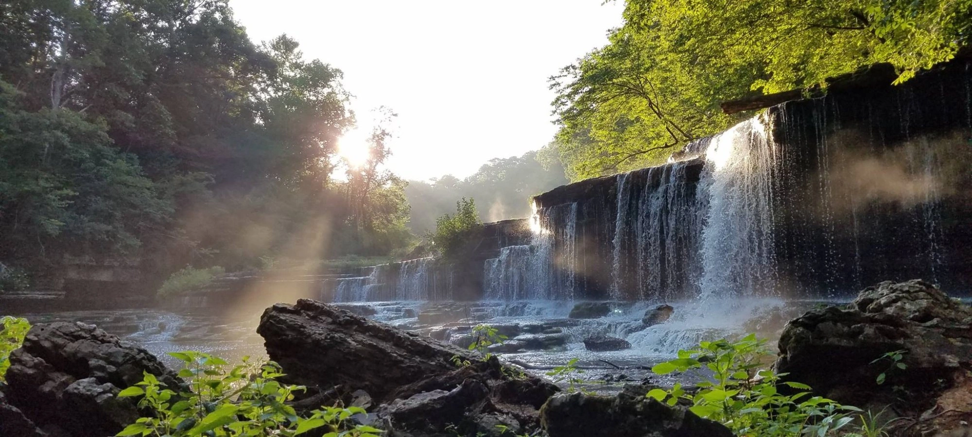
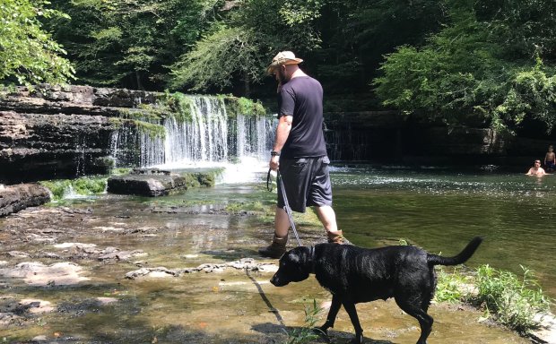
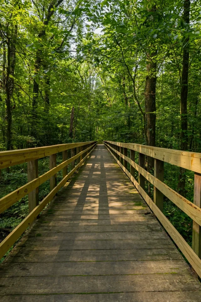
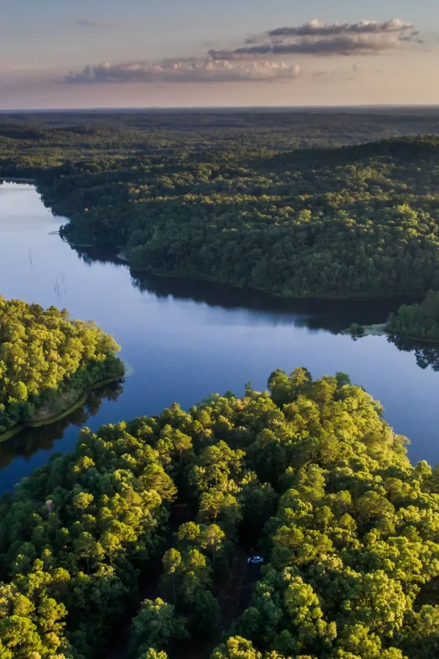
    Hiking at Old Stone Fort 

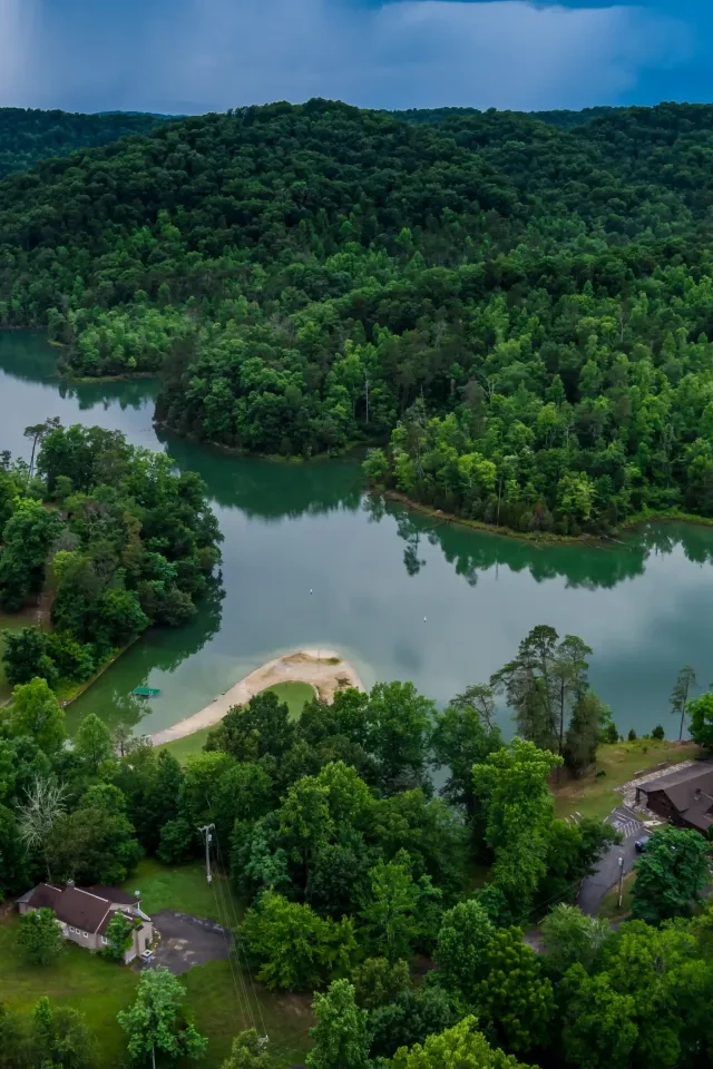
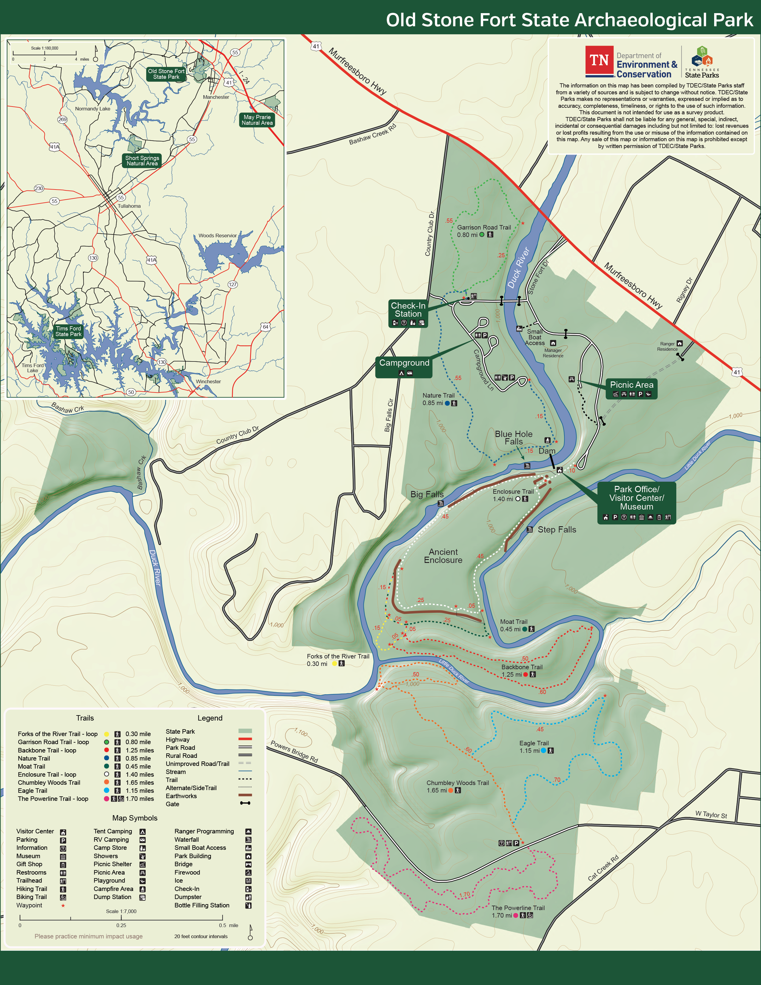
    Old Stone Fort State Archaeological Park has several miles of hiking trails at all levels of difficulty.

    Trails

    Showing page 1 of 2
    • Adams Falls Trail

      Old Stone Fort State Archaeological Park
      Distance
      Difficulty
      Surface
      Natural
      Availability
      Open
      Allowed
      Hiking

      Backbone Trail

      Old Stone Fort State Archaeological Park
      Distance
      1.25 mi.
      Difficulty
      Difficult
      Surface
      Natural
      Also known as the Little Duck River Loop Trail, this is an extension of the main interpretive path. Backbone Ridge is a remarkable erosional feature that separates the long abandoned channel from the current channel of the Little Duck River. The ridge may have had its own ceremonial significance to the enclosure builders.
      Availability
      Open
      Allowed
      Hiking

      Bobo Creek Trail

      Old Stone Fort State Archaeological Park
      Distance
      Difficulty
      Surface
      Natural
      Availability
      Open
      Allowed
      Hiking

      Chumbley Woods Trail

      Old Stone Fort State Archaeological Park
      Distance
      1.65 mi.
      Difficulty
      Surface
      Natural
      Availability
      Open
      Allowed
      Hiking

      Eagle Trail

      Old Stone Fort State Archaeological Park
      Distance
      1.15 mi.
      Difficulty
      Surface
      Natural
      Availability
      Open
      Allowed
      Hiking

      Enclosure Trail

      Old Stone Fort State Archaeological Park
      Distance
      1.40 mi.
      Difficulty
      Difficult
      Surface
      Natural
      The enclosure trail surrounds a unique geological feature that was used by Woodland Indians 2,000 years ago. It offers views of the park's three largest waterfalls - Step Falls, Blue Hole Falls, and Big Falls. The path is a loop that follows the perimeter of the mound site, traveling along the deep gorges cut by the rivers on either side of the site. It first goes between the two pedestal mounds flanking an entrance to the enclosure.
      Availability
      Open
      Allowed
      Hiking

      Enclosure Trail

      Old Stone Fort State Archaeological Park
      The enclosure trail surrounds a unique geological feature that was used by Woodland Indians 2,000 years ago. It offers views of the park's three largest waterfalls - Step Falls, Blue Hole Falls, and Big Falls. The path is a loop that follows the perimeter of the mound site, traveling along the deep gorges cut by the rivers on either side of the site. It first goes between the two pedestal mounds flanking an entrance to the enclosure.
      Distance
      1.40 mi.
      Difficulty
      Difficult
      Surface
      Natural
      Allowed
      Hiking

      Trail Type
      Information unavailable

      Elevation
      Gain 175.30'
      Loss 151.30'
      Grade
      Typical 3.7%
      Max 26.2%
      Cross Slope
      Typical 2.4%
      Max 16.0%
      Tread Width
      Typical 49"
      Minimum 11"
      Surface Type
      Soil 78.9%; Gravel 11.9%; Wood decking 2.3%; Rock 2.2%; Bedrock 1.6%; Stairs 1.6%; Paved 1.5%
      Obstructions Exist
      Rock step: 13 in tall; Tree root: 12 in tall; Staircase: 11 in tall

      Forks of the River Trail

      Old Stone Fort State Archaeological Park
      Distance
      0.30 mi.
      Difficulty
      Difficult
      Surface
      Natural
      This trail is nestled in a bottomland hardwood forest and offers a view of the river where the Duck and Little Duck Rivers meet.This is a pleasant walk off the Enclosure Trail to where the Big Duck River and the Little Duck River meet to form the Duck River. The Duck River has been recognized by National Geographic Magazine as one of the five most biodiverse rivers in the entire world.
      Availability
      Open
      Allowed
      Hiking

      Forks of the River Trail

      Old Stone Fort State Archaeological Park
      This trail is nestled in a bottomland hardwood forest and offers a view of the river where the Duck and Little Duck Rivers meet.This is a pleasant walk off the Enclosure Trail to where the Big Duck River and the Little Duck River meet to form the Duck River. The Duck River has been recognized by National Geographic Magazine as one of the five most biodiverse rivers in the entire world.
      Distance
      0.30 mi.
      Difficulty
      Difficult
      Surface
      Natural
      Allowed
      Hiking

      Trail Type
      Information unavailable

      Elevation
      Gain 36.30'
      Loss 86.80'
      Grade
      Typical 6.3%
      Max 23.5%
      Cross Slope
      Typical 1.9%
      Max 12.7%
      Tread Width
      Typical 49"
      Minimum 24"
      Surface Type
      Soil 64%; Gravel 31.2%; Bedrock 4.8%
      Obstructions Exist
      Rock steps: 9 in tall; Tree roots: 8 in tall; Tree roots: 8 in tall

      Garrison Road Trail

      Old Stone Fort State Archaeological Park
      Distance
      0.80 mi.
      Difficulty
      Difficult
      Surface
      Natural
      This trailhead is also behind the camper check-in building. The name refers to a fort from the very early 1800s called Purdies Garrison. The road served as a route of the Nickajack Trace as it ran from the Purdies Garrison to the area of the Old Stone Fort. You will also walk a short stretch on the earliest paved section of Highway 41, now lost in the woods. This route returns across a pleasant area on higher ground.
      Availability
      Open
      Allowed
      Hiking

      Garrison Road Trail

      Old Stone Fort State Archaeological Park
      This trailhead is also behind the camper check-in building. The name refers to a fort from the very early 1800s called Purdies Garrison. The road served as a route of the Nickajack Trace as it ran from the Purdies Garrison to the area of the Old Stone Fort. You will also walk a short stretch on the earliest paved section of Highway 41, now lost in the woods. This route returns across a pleasant area on higher ground.
      Distance
      0.80 mi.
      Difficulty
      Difficult
      Surface
      Natural
      Allowed
      Hiking

      Trail Type
      Information unavailable

      Elevation
      Gain 103.60'
      Loss 104.50'
      Grade
      Typical 4.8%
      Max 31.8%
      Cross Slope
      Typical 3.1%
      Max 19.9%
      Tread Width
      Typical 52"
      Minimum 16"
      Surface Type
      Soil 73.7%; Gravel 13.6%; Asphalt 10.6%; Wood decking 1.3%; Stairs 0.8%
      Obstructions Exist
      Staircase: 12 in tall; Step: 9 in tall; Tree: 16 in of tread remaining

      John A. Patten Island Water Trail

      Old Stone Fort State Archaeological Park
      Distance
      Difficulty
      Surface
      Natural
      Availability
      Open
      Allowed
      Hiking
    • Lakefront Water Trail

      Old Stone Fort State Archaeological Park
      Distance
      Difficulty
      Surface
      Natural
      Availability
      Open
      Allowed
      Hiking

      Laurel Bluff Trail

      Old Stone Fort State Archaeological Park
      Distance
      Difficulty
      Surface
      Natural
      Availability
      Open
      Allowed
      Hiking

      Machine Falls Loop Trail

      Old Stone Fort State Archaeological Park
      Distance
      Difficulty
      Surface
      Natural
      Availability
      Open
      Allowed
      Hiking

      Moat Trail

      Old Stone Fort State Archaeological Park
      Distance
      0.45 mi.
      Difficulty
      Difficult
      Surface
      Natural
      Also known as the Old River Channel Trail, this trail connects to the Forks of the River Trail and the Enclosure Trail. The trail traverses an abandoned river channel below the western wall of the Old Stone Fort.
      Availability
      Open
      Allowed
      Hiking

      Moat Trail

      Old Stone Fort State Archaeological Park
      Also known as the Old River Channel Trail, this trail connects to the Forks of the River Trail and the Enclosure Trail. The trail traverses an abandoned river channel below the western wall of the Old Stone Fort.
      Distance
      0.45 mi.
      Difficulty
      Difficult
      Surface
      Natural
      Allowed
      Hiking

      Trail Type
      Information unavailable

      Elevation
      Gain 37.50'
      Loss 62.20'
      Grade
      Typical 4.6%
      Max 44.3%
      Cross Slope
      Typical 1.3%
      Max 12.2%
      Tread Width
      Typical 50"
      Minimum 12"
      Surface Type
      Soil 61%; Bedrock 19.8%; Gravel 19.2%
      Obstructions Exist
      Rock: 14 in tall; Rock: 12 in tall; Rock steps: 9 in tall

      Nature Trail

      Old Stone Fort State Archaeological Park
      Distance
      0.85 mi.
      Difficulty
      Difficult
      Surface
      Natural
      This one mile trail encircles the campground and is a great place to see and hear woodland bird species. Located behind by the camper check-in station, this trail offers a pleasant walk through the woods and returns through the back end of the campground. A short portion passes near the Duck River.
      Availability
      Open
      Allowed
      Hiking

      Nature Trail

      Old Stone Fort State Archaeological Park
      This one mile trail encircles the campground and is a great place to see and hear woodland bird species. Located behind by the camper check-in station, this trail offers a pleasant walk through the woods and returns through the back end of the campground. A short portion passes near the Duck River.
      Distance
      0.85 mi.
      Difficulty
      Difficult
      Surface
      Natural
      Allowed
      Hiking

      Trail Type
      Information unavailable

      Elevation
      Gain 59.10'
      Loss 68.90'
      Grade
      Typical 2.7%
      Max 38.9%
      Cross Slope
      Typical 2.0%
      Max 15.2%
      Tread Width
      Typical 56"
      Minimum 20"
      Surface Type
      Soil 73.9%; Gravel 19.4%; Wood decking 6.2%; Asphalt 0.5%
      Obstructions Exist
      Step: 12 in tall; Step: 12 in tall; Tree roots: 7 in tall

      The Powerline Trail

      Old Stone Fort State Archaeological Park
      Distance
      1.70 mi.
      Difficulty
      Surface
      Natural
      Availability
      Open
      Allowed
      Hiking Mountain Biking

      Wildflower Loop Trail

      Old Stone Fort State Archaeological Park
      Distance
      Difficulty
      Surface
      Natural
      Availability
      Open
      Allowed
      Hiking

      Wolftever Rabbit Island Water Trail

      Old Stone Fort State Archaeological Park
      Distance
      Difficulty
      Surface
      Natural
      Availability
      Open
      Allowed
      Hiking

    Trail Definitions

    • Cross Slope 

      Describes the degree of incline from one side of the trail path to the other; measured as a percentage. Cross slope aids in water drainage and impacts the overall trail stability.   

    • Grade  

      Describes the rise in elevation over a horizontal distance on the trail; measured as a percentage.  Higher percentages represent a steeper grade indicating a more challenging ascent or descent for hikers.    

    • Standard Ramp Grade

      Serves as a reference guide for the grade of the trail.  Standard Ramp Grade is 8.3% across all trail assessments.  

    • Surface 

      A characteristic of the trail expressed in terms of material type, grading, compaction, and roughness of the path. Possible surface types include soil, gravel, paved, and mulch.   

    • Tread Width    

      Represents the horizontal distance from one edge of the trail path to the other; measurements can vary.  Tread width helps to determine the amount of space a hiker has to pass through. Obstacles on the trail can alter the remaining tread width.   

    • Trail Types: Loop

      Trail returns at or near the point from which you started. 

    • Trail Types: Network 

      Offers multiple route options within one trail, and each route is connected

    • Trail Types: Out and Back

      This type of trail travels out to an endpoint where hikers turn around and travel back to the starting point.   

    • Trail Types: Stacked Loop

      A loop trail contained completely within another trail.   

    Need a Map?

    Explore our collection of printable and digital trail maps, organized by park. Whether you’re hiking, camping, or paddling, you’ll find the resources you need to navigate confidently.


    Visitor Center Gift Shop

    The Visitor Center Gift Shop is the perfect place to pick up a map, learn about the park, or find a souvenir. You’ll find an assortment of apparel and keepsakes to remember your trip to the park.

    Address:
    732 Stone Fort Drive, Manchester TN, 37355
    1-931-461-7676

    Hours: 
    8:00 AM - 4:30 PM

    Skip photo gallery
    Media Crowdriff
    Happenings

    Other Activities at Old Stone Fort State Archaeological Park