Cumberland Mountain Hiking

  • Arched stone bridge spanning a calm lake, surrounded by vibrant fall foliage in shades of orange, yellow, and green, with reflections in the water.
  • Man carrying a toddler and walking with an older child along a narrow, tree-lined forest path next to a calm lake.

    Hiking at Cumberland Mountain

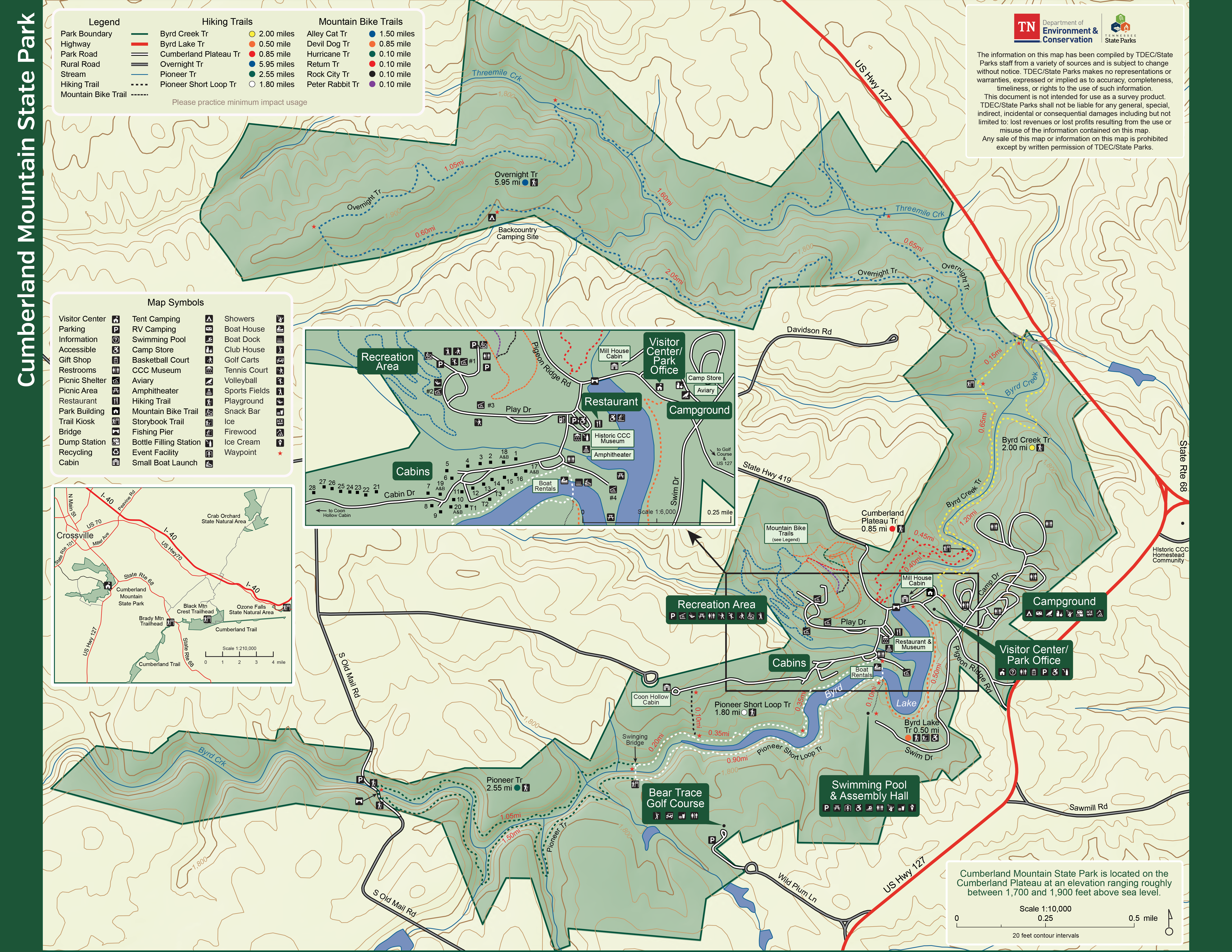
    Cumberland Mountain State Park has approximately 14 miles of trail around the lake, creek, and through the woods. Hikes range from easy to moderate day or overnight hiking experiences. Trail maps are available at the park office. 

    Trails

    Showing page 1 of 2
    • Alley Cat Trail

      Cumberland Mountain State Park
      Distance
      1.50 mi.
      Difficulty
      Surface
      Natural
      Availability
      Open
      Allowed
      Mountain Biking

      Byrd Creek Trail

      Cumberland Mountain State Park
      Distance
      2.00 mi.
      Difficulty
      Moderate
      Surface
      Natural
      This trail follows along the banks of Byrd Creek for the entirety of the hike. At approximately one and a half miles hikers will come to the red and yellow junction. From here you should follow the red trail back to the CCC dam, then walk across the dam back to the park office where you started. This trail provides hikers with a unique tree top canopy of hemlock trees in several sections. Through these sections you will notice less vegetation on the forest floor and cooler temperatures in these areas. Hikers will also cross a small creek that is home to a very unique bridge that was built by an eagle scout.
      Availability
      Open Seasonal
      Allowed
      Hiking

      Byrd Lake Trail

      Cumberland Mountain State Park
      Distance
      0.50 mi.
      Difficulty
      Difficult
      Surface
      Paved
      This is the shortest hike on the park and is ADA accessible. The flexible porous pavement is ideal for wheelchairs, walkers and strollers. The trail winds around Byrd Lake to our foot bridge at the boat dock. This trail is great for viewing waterfowl and songbirds.
      Availability
      Open
      Allowed
      Hiking wheelchair

      Byrd Lake Trail

      Cumberland Mountain State Park
      This is the shortest hike on the park and is ADA accessible. The flexible porous pavement is ideal for wheelchairs, walkers and strollers. The trail winds around Byrd Lake to our foot bridge at the boat dock. This trail is great for viewing waterfowl and songbirds.
      Distance
      0.50 mi.
      Difficulty
      Difficult
      Surface
      Paved
      Allowed
      Hiking wheelchair

      Trail Type
      Information unavailable

      Elevation
      Gain 18.90'
      Loss 45.40'
      Grade
      Typical 2.5%
      Max 11.6%
      Cross Slope
      Typical 1.6%
      Max 7.5%
      Tread Width
      Typical 100"
      Minimum 50"
      Surface Type
      Asphalt 97.9%; Aluminum 2.1%
      Obstructions Exist
      Posts: 50 in of tread remaining

      Cumberland Plateau Trail

      Cumberland Mountain State Park
      Distance
      0.85 mi.
      Difficulty
      Moderate
      Surface
      Natural
      This trail showcases a variety of wildflowers throughout the year. It is one of the most easily accessible trails to view the pink lady’s slipper in the late spring. This trail takes hikers through dense forest on the upper section of trail and loops around to follow the creek on the lower section of trail. The trail completes the loop with a very picturesque view of the backside of the CCC Dam and Mill House Lodge.
      Availability
      Open Seasonal
      Allowed
      Hiking

      Devil Dog Trail

      Cumberland Mountain State Park
      Distance
      0.85 mi.
      Difficulty
      Surface
      Natural
      Availability
      Open
      Allowed
      Mountain Biking

      Hurricane Trail

      Cumberland Mountain State Park
      Distance
      0.10 mi.
      Difficulty
      Surface
      Natural
      Availability
      Open
      Allowed
      Mountain Biking

      Overnight Trail

      Cumberland Mountain State Park
      Distance
      5.95 mi.
      Difficulty
      Difficult
      Surface
      Natural
      This trail is accessed by hiking the Bryd Creek Trail to the blue and yellow junction. From here the overnight trail begins; a six mile loop trail that provides hikers with a dense forest surrounding them. The forest is made up of mostly oaks, hickory, sourwood, black gum, Virginia pine and white pines. You should be prepared to cross a swinging bridge and several creeks and streams along this loop trail. In the late spring, the overnight trail is home to a grove of pink lady’s slippers. The overnight campsite is located on this trail. Please register at the park office before camping.
      Availability
      Open
      Allowed
      Hiking

      Peter Rabbit Trail

      Cumberland Mountain State Park
      Distance
      0.10 mi.
      Difficulty
      Surface
      Natural
      Availability
      Open
      Allowed
      Mountain Biking

      Pioneer Short Loop Trail

      Cumberland Mountain State Park
      Distance
      1.80 mi.
      Difficulty
      Difficult
      Surface
      Natural
      This is the most frequently hiked trail in our park. The trail follows along the banks of Byrd Lake to our famous swinging bridge and loops back around to our foot bridge at the boat dock. Along the trail,you will see a small rock overlook we call picnic rock. Stop here and enjoy the view. Hikers will pass through several sections of trail where mountain laurel and rhododendron create a pathway along the trail. The long section of rock steps that hikers will go up and down are original steps put in by the Civilian Conservation Corps.
      Availability
      Open
      Allowed
      Hiking

      Pioneer Short Loop Trail

      Cumberland Mountain State Park
      This is the most frequently hiked trail in our park. The trail follows along the banks of Byrd Lake to our famous swinging bridge and loops back around to our foot bridge at the boat dock. Along the trail,you will see a small rock overlook we call picnic rock. Stop here and enjoy the view. Hikers will pass through several sections of trail where mountain laurel and rhododendron create a pathway along the trail. The long section of rock steps that hikers will go up and down are original steps put in by the Civilian Conservation Corps.
      Distance
      1.80 mi.
      Difficulty
      Difficult
      Surface
      Natural
      Allowed
      Hiking

      Trail Type
      Information unavailable

      Elevation
      Gain 261.40'
      Loss 242.90'
      Grade
      Typical 4.8%
      Max 32.6%
      Cross Slope
      Typical 3.2%
      Max 20.9%
      Tread Width
      Typical 29"
      Minimum 10"
      Surface Type
      Soil 81.4%; Large rock 11.1%; Wood decking 3.2%; Asphalt 3.2%; Stairs 1.2%
      Obstructions Exist
      Rock: 11 in tall; Tree root: 11 in tall; Stump: 10 in of tread remaining
    • Pioneer Trail

      Cumberland Mountain State Park
      Distance
      2.55 mi.
      Difficulty
      Moderate
      Surface
      Natural
      Accessed by hiking the Pioneer Short Loop Trail, this trail begins just past the swinging bridge. The trail is a three mile loop that follows Byrd Creek upstream to a one lane sandstone arch bridge built by the CCC. The trail crosses the bridge and and then returns on the opposite side of the creek. Along this section of trail you will see a variety of rock overhangs and unique rock outcroppings. Hikers will also pass through our fat-man squeeze if you are lucky! The trail provides numerous opportunities to view a variety of plants, trees, and wildlife.
      Availability
      Open
      Allowed
      Hiking

      Return Trail

      Cumberland Mountain State Park
      Distance
      0.10 mi.
      Difficulty
      Surface
      Natural
      Availability
      Open
      Allowed
      Mountain Biking

      Rock City Trail

      Cumberland Mountain State Park
      Distance
      0.10 mi.
      Difficulty
      Surface
      Natural
      Availability
      Open
      Allowed
      Mountain Biking

    Trail Definitions

    • Cross Slope 

      Describes the degree of incline from one side of the trail path to the other; measured as a percentage. Cross slope aids in water drainage and impacts the overall trail stability.   

    • Grade  

      Describes the rise in elevation over a horizontal distance on the trail; measured as a percentage.  Higher percentages represent a steeper grade indicating a more challenging ascent or descent for hikers.    

    • Standard Ramp Grade

      Serves as a reference guide for the grade of the trail.  Standard Ramp Grade is 8.3% across all trail assessments.  

    • Surface 

      A characteristic of the trail expressed in terms of material type, grading, compaction, and roughness of the path. Possible surface types include soil, gravel, paved, and mulch.   

    • Tread Width    

      Represents the horizontal distance from one edge of the trail path to the other; measurements can vary.  Tread width helps to determine the amount of space a hiker has to pass through. Obstacles on the trail can alter the remaining tread width.   

    • Trail Types: Loop

      Trail returns at or near the point from which you started. 

    • Trail Types: Network 

      Offers multiple route options within one trail, and each route is connected

    • Trail Types: Out and Back

      This type of trail travels out to an endpoint where hikers turn around and travel back to the starting point.   

    • Trail Types: Stacked Loop

      A loop trail contained completely within another trail.   

    Need a Map?

    Explore our collection of printable and digital trail maps, organized by park. Whether you’re hiking, camping, or paddling, you’ll find the resources you need to navigate confidently.


    Visitor Center Gift Shop

    The Visitor Center Gift Shop is the perfect place to pick up a map, learn about the park, or find a souvenir. You’ll find an assortment of apparel and keepsakes to remember your trip to the park.  

    Address:
    24 Office Drive, Crossville TN, 38555

    Hours
    8:00 AM – 4:30 PM  

    Skip photo gallery
    Media Crowdriff
    Happenings

    No events are scheduled at this time, but there's always more to explore.

    Find More Events